⚡ In short
Why were these sites chosen for Japan's "100 Best Springs"? We explain the aquifers and terrain that produce spring water, the origins of famous springs like the Kakita River and Kokubunji, and how urbanization has erased springs and what's being done to protect them.
A spring-fed park near a train station, or a pond brimming with crystal-clear water — many people have seen a sign marking one of Japan's "100 Best Springs." But few could explain why water rises to the surface at that exact spot and nowhere else.
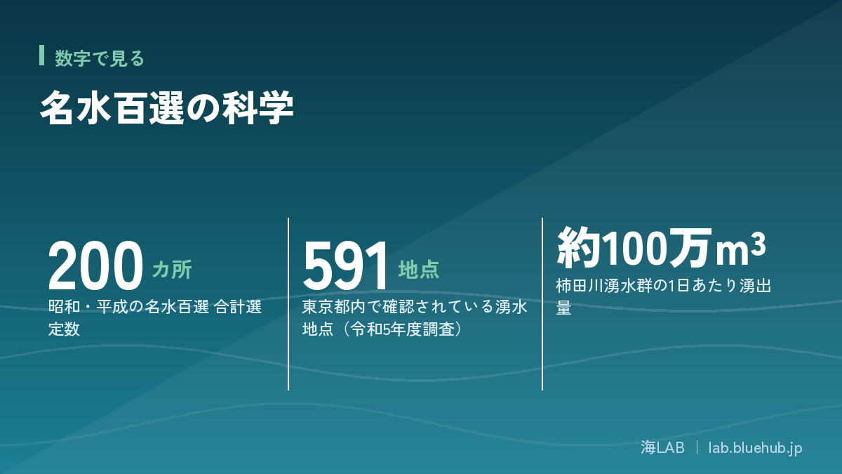
A spring is not there by chance. It is a place where groundwater moving underground appears at the surface, and this only happens where the right combination of terrain and geology exists. All 200 locations across Japan's "100 Best Springs," selected by the Ministry of the Environment in 1985, and the "Heisei 100 Best Springs," added in 2008, sit on land that satisfies these conditions.
This article draws on primary sources to explain what the "100 Best Springs" program actually is, the geological mechanism behind how springs form, the origins of some of Japan's best-known springs, the reality of springs disappearing due to urbanization, and the conservation efforts working to stop that loss.
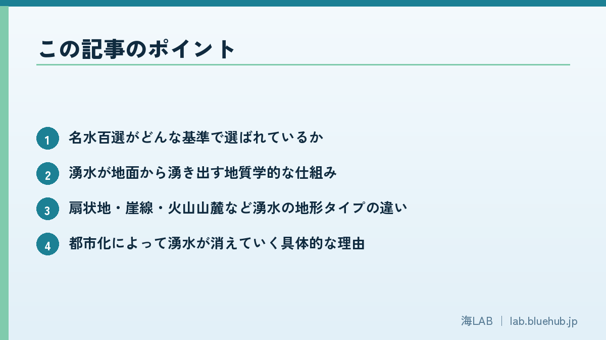
What you'll learn in this article
- The criteria used to select Japan's "100 Best Springs"
- The geological mechanism by which spring water rises to the surface
- The differences between spring types found on alluvial fans, escarpments, and volcanic foothills
- The concrete reasons urbanization causes springs to disappear
- The systems and activities communities use to protect springs
- How springs connect to ecosystems, faith, and water-source forests
What Is the "100 Best Springs" Program?
Japan's "100 Best Springs" (Meisui Hyakusen) is a list of 100 representative springs, rivers, groundwater sources, and irrigation channels selected nationwide in 1985 by the Environment Agency (now the Ministry of the Environment). It is important to understand that this is not simply a "tastiest water" ranking — it is a program aimed at conserving water environments.
A Ministry of the Environment program launched in 1985
At the time of selection, rapid industrial and household wastewater pollution and large-scale reclamation and development during Japan's period of high economic growth were rapidly degrading rivers and groundwater nationwide. The program aimed to build momentum for preserving good water environments for future generations. The Kakita River (Shizuoka Prefecture), the Otaka-no-michi and Masugata-no-ike springs (Kokubunji, Tokyo), and Oshino Hakkai (Yamanashi Prefecture) were among the first sites selected.
At the time, the sense that "water is something you can get anywhere for free" still ran deep in society. Against that backdrop, the Environment Agency's move to make the value of water environments visible again, and to pose that question to society, gave the "100 Best Springs" program its pioneering significance.
Selections were made based on nominations from each prefecture, taking into account the opinions of water quality and quantity experts and local governments. Beyond simply having good water quality test results, the narrative of how a community has used and passed down the story of its water became an important factor in selection.
The criteria go beyond "water quality"
Selection was based on multiple evaluation axes: "water quality and quantity," "surrounding ecology and conservation status," "accessibility and closeness to the water," "usage patterns and traditions," "conservation activities," and "historical anecdotes and rarity." What stands out is that it isn't just about clean water — how the local community has protected and used that water environment is given serious weight.
The Heisei list brought the total to 200 sites
In June 2008, a new set of 100 sites that did not overlap with the 1985 selections was chosen as the "Heisei 100 Best Springs," bringing the combined total to 200 sites known as the "100 Best Springs." The Heisei selection included a wider variety of water sources beyond rivers and springs, such as groundwater and agricultural irrigation channels.
Key points of the Heisei 100 Best Springs (2008)
- 100 new sites selected, with no overlap with the 1985 list
- Included diverse water sources beyond rivers and springs, such as groundwater and irrigation channels
- Particular emphasis was placed on "proactive, ongoing conservation activities by local residents"
- Combined with the 1985 list, 200 sites nationwide now make up the "100 Best Springs"
Spring-fed "100 Best Springs" from Hokkaido to the Kansai region
Among the "100 Best Springs," those fed by spring water are distributed across Japan, from Hokkaido to Kyushu. Lining up springs from regions with different terrain and climates shows just how varied the phenomenon of a "spring" can be.
| Name | Location | Characteristics |
|---|---|---|
| Yotei Fukidashi Spring | Kyogoku, Hokkaido | Water temperature about 6.5°C; discharges about 80,000 tons per day |
| Azumino Wasabida Spring Cluster | Azumino, Nagano Prefecture | Underflow from the Northern Alps; source of water for wasabi cultivation |
| Otaka-no-michi and Masugata-no-ike Springs | Kokubunji, Tokyo | Escarpment spring on the Musashino Plateau |
| Kakita River Spring Cluster | Shimizu, Shizuoka Prefecture | Underflow from Mt. Fuji; about 1,000,000 m³ per day |
| Oshino Hakkai | Oshino, Yamanashi Prefecture | Underflow from Mt. Fuji; eight ponds, part of a UNESCO World Heritage component asset |
| Nunobiki Ravine | Kobe, Hyogo Prefecture | Fault fracture zone spring in the Rokko mountain system |
How Springs Are Formed
A spring is a phenomenon in which groundwater moving underground naturally emerges at the surface for some reason. Understanding this requires knowing how groundwater accumulates underground and in which direction it moves.
Aquifers and unconfined groundwater
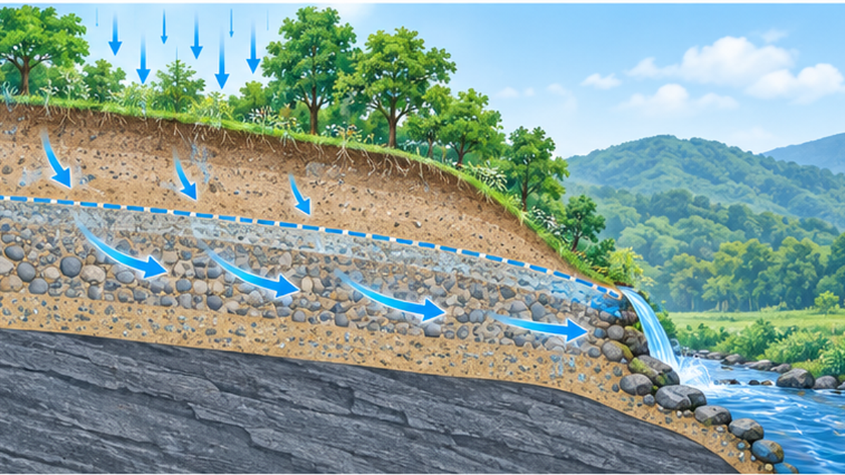
Rain and melted snow seep from the surface into the ground and accumulate in permeable layers of sand and gravel called "aquifers." When there is no impermeable layer (confining layer) above an aquifer and the water table can rise and fall freely, it is called an "unconfined aquifer," and the groundwater it holds is called "unconfined groundwater." Unconfined groundwater is relatively shallow groundwater whose water table height fluctuates with rainfall patterns and the seasons.
The hydraulic head difference that drives water upward
Groundwater has higher pressure (hydraulic head) at higher elevations and moves toward lower elevations following physical law (Darcy's Law). This head difference is precisely what pushes water up to the surface. Rainwater seeps into the ground at the top of mountains or plateaus, then moves through the aquifer over a period ranging from several years to several decades, eventually surfacing at the low end of a valley or the base of a cliff.
Discharge through faults and fractures
Beyond the edges of flat aquifers, faults and cracks in bedrock (fractures) can also serve as pathways for groundwater, causing water to gush out intensively at those points. The spring clusters at the foot of Mt. Fuji, where underflow travels through cracks in lava, are a classic example of this.
The long time lag between recharge and discharge
The water gushing out of a spring right now is by no means yesterday's rain. At the foot of Mt. Fuji, rain and melted snow are said to take roughly 26 to 28 years to travel underground, meaning the clear water we see today fell as rain decades ago. This long time lag is exactly what makes springs a resource that "cannot easily be restored once it dries up."
Whether a spring's discharge is stable or vulnerable to seasonal changes and drought also depends on the size of the "recharge area" that captures rainwater and the storage capacity of the aquifer. Land with a wide recharge area and a thick aquifer tends to maintain stable discharge even during dry spells. Conversely, when a recharge area is narrowed by urban development, spring discharge tends to drop sharply during droughts.
Terrain Types That Produce Springs
Looking across Japan's "100 Best Springs," several typical patterns emerge in the terrain that produces them.
Springs at the toe of alluvial fans
An alluvial fan forms where a river flows out of the mountains onto a plain. In the central part of the fan, the river's water sinks underground (becomes underflow), then resurfaces at the toe of the fan, where the slope levels out. Nagano Prefecture's "Azumino Wasabida Spring Cluster" is a classic example of this fan-toe type: underflow from the Northern Japan Alps creates clear spring ponds throughout the rice-growing area and is also known as the water source for wasabi cultivation. Selected for the "100 Best Springs" list in 1985, it took first place in both the sightseeing and scenery categories of the 2016 "100 Best Springs Election."
Springs from escarpments (terrace cliffs)
At the boundary between a plateau and lowland, a cliff (terrace cliff or escarpment) forms, and rainwater that has seeped into the plateau seeps back out as groundwater on the cliff's slope. Tokyo's Kokubunji Escarpment and the spring clusters of Setagaya belong to this terrain type. The Musashino Plateau has a structure in which sand and gravel layers lie beneath a loam layer, and this boundary is geologically prone to becoming a discharge surface.
Underflow at volcanic foothills
At the foot of a volcano like Mt. Fuji, rainwater slowly seeps through gaps in basalt lava and volcanic gravel, taking a long time to emerge from various points at the base of the mountain. The Kakita River and Oshino Hakkai are both of this type. Because the gaps in lava have both high permeability and strong filtering ability, spring water at volcanic foothills is generally known for its high transparency. The "Yotei Fukidashi Spring" that flows from the foot of Mt. Yotei in Hokkaido shares this same origin, and is notably cold, with a year-round water temperature of about 6.5°C.
Springs from fault fracture zones
Within a mountain range itself, a "fault fracture zone," where bedrock has been shattered by fault movement, can serve as both a pathway and a reservoir for groundwater, causing it to emerge as a spring on the mountainside. Kobe's Nunobiki Ravine in Hyogo Prefecture is of this type, gathering groundwater from the fault fracture zones common in the Rokko mountain system. Natural filtration through layers of granite sand, gravel, and silt produces soft water containing minerals. In the Meiji era, it was reportedly a favorite of sailors on foreign ships calling at Kobe Port, who praised it for tasting the same even after crossing the equator.
| Spring type | Representative terrain | Representative example |
|---|---|---|
| Fan-toe spring | Toe of an alluvial fan | Azumino (Nagano Prefecture) |
| Escarpment spring | Cliff at the boundary of a plateau and lowland | Kokubunji Escarpment (Tokyo) |
| Volcanic foothill spring | Base of a volcano | Kakita River, Oshino Hakkai (Shizuoka, Yamanashi), Yotei Fukidashi Spring (Hokkaido) |
| Fault fracture zone spring | Fault fracture zone in a mountain range | Nunobiki Ravine (Kobe, Hyogo Prefecture) |
Even though it's all called "spring water," the stability of discharge, water quality tendencies, and even the surrounding scenery change depending on the terrain that produced it. When visiting one of the "100 Best Springs," paying attention to which type it belongs to will change the way you see it.
The Science Behind Famous "100 Best Springs"
Let's look at four examples from among the "100 Best Springs" that are especially high in discharge and clearly illustrate their geological origins. Even though they're all "spring water," you'll see that water temperature, discharge volume, and water hardness differ completely from place to place.
Kakita River spring cluster (Shizuoka) — underflow from Mt. Fuji
The Kakita River, at only about 1.2km long, is considered Japan's shortest Class A river, yet boasts an abundant discharge of roughly 1,000,000 m³ per day and is counted among Japan's three great clear-water rivers, alongside the Nagara and Shimanto Rivers. Rain and melted snow falling on Mt. Fuji travel through basalt lava and volcanic gravel for roughly 26 to 28 years before emerging at the Kakita River's spring outlets. Its water temperature stays nearly constant year-round at about 15°C, and it was designated part of the "100 Best Springs" as the Kakita River spring cluster in 1985.
Otaka-no-michi and Masugata-no-ike springs (Kokubunji, Tokyo) — a gift of the Musashino Plateau
Representing the springs of the Kokubunji Escarpment are the "Otaka-no-michi and Masugata-no-ike springs" in Kokubunji, Tokyo. Rainwater that falls on the Musashino Plateau becomes groundwater and seeps out on the slope of the escarpment, which the Tama River carved out over a long span of time. Selected for the "100 Best Springs" in 1985, the surrounding area also contains springs such as Sugatami-no-ike Pond and the spring at Tonogayato Garden, both counted among "Tokyo's 57 Notable Springs," discussed later in this article. It is considered rare nationwide for such a concentrated cluster of springs to remain intact within an urban area.
Oshino Hakkai (Yamanashi) — the story of Mt. Fuji's snowmelt
Oshino Hakkai, in the village of Oshino, Yamanashi Prefecture, is another famous spring fed by underflow from Mt. Fuji, just like the Kakita River. It consists of eight ponds — Deguchi-ike, Okama-ike, Sokonashi-ike, Choshi-ike, Waku-ike, Nigori-ike, Kagami-ike, and Shobu-ike — all holding remarkably clear water. In the Edo period, it was revered as a pilgrimage site where people purified themselves before climbing Mt. Fuji, and in 2013 it was registered as a UNESCO World Heritage component asset under "Fujisan, sacred place and source of artistic inspiration."
Yotei Fukidashi Spring (Hokkaido) — a cool volcanic spring
The "Yotei Fukidashi Spring" in Kyogoku, Hokkaido, is a famous spring where rain and snow falling on the 1,898-meter Mt. Yotei seep underground over a long period and emerge from a spring outlet at the mountain's base. Its discharge is estimated at about 80,000 tons per day, equivalent to the daily water use of roughly 300,000 people. Its water temperature stays notably cold year-round at about 6.5°C, and its hardness is around 23mg/L, classifying it as soft water. In addition to being named to the "100 Best Springs" in 1985, it was also designated a Hokkaido Heritage site in 2001. The stark difference in water temperature compared to the springs at the foot of Mt. Fuji (about 15°C), despite both being volcanic foothill springs, reflects differences in the volcano's elevation, snowfall, and how long groundwater lingers underground.
How Urbanization Has Erased Springs
While springs selected for the "100 Best Springs" have been protected, many springs in urban areas have disappeared over the past several decades.
More than 180 sites disappeared in the 23 wards of Tokyo
According to the Tokyo Metropolitan Government's "Groundwater Survey Report" (September 1992), more than 180 spring sites, mainly within the 23 wards, have disappeared compared to the Meiji era. On the other hand, a fiscal year 2023 survey confirmed 591 spring sites still existing within Tokyo (199 in the wards, 392 in the cities and towns), and abundant springs still remain in the hills and escarpments of the Tama area.
70 sites lost in just five years
There is also concrete evidence of just how quickly urbanization can erode springs. Of the 653 spring sites Tokyo confirmed in fiscal year 1995, roughly 70 had already disappeared by the time of a fiscal year 2000 survey. Alarmed by this, Tokyo Metropolitan Government selected and published "Tokyo's 57 Notable Springs" in January 2003, aiming to raise public interest in springs and promote their protection and recovery.
How pavement and asphalt cut off "recharge"
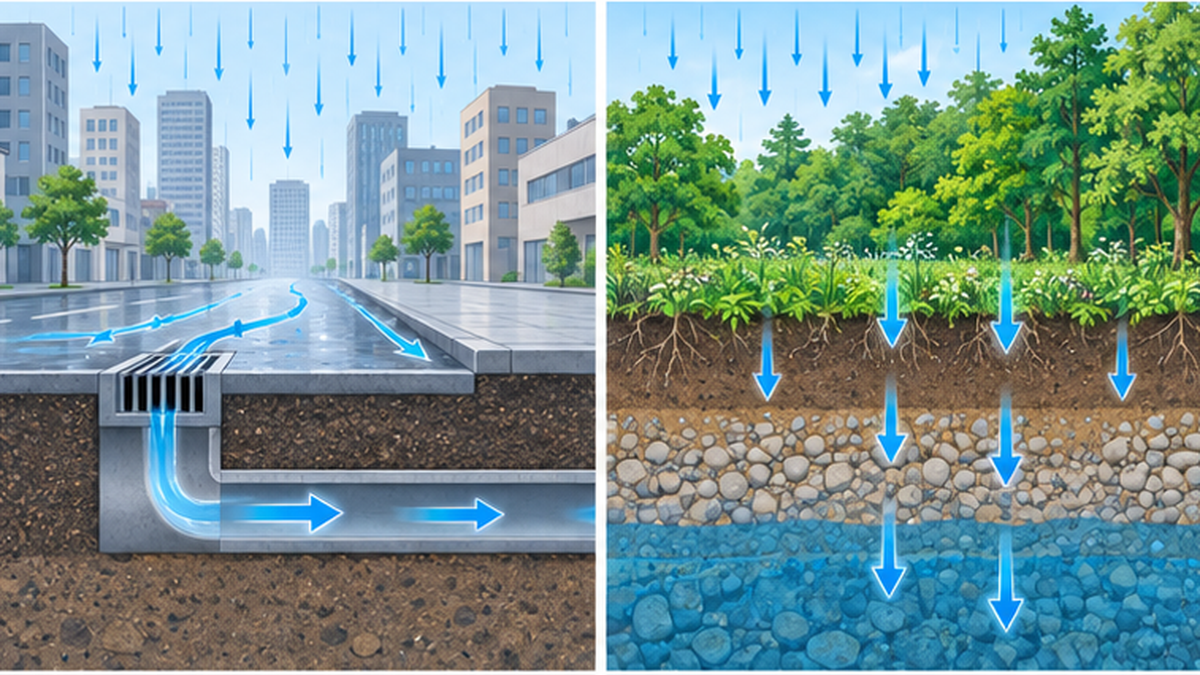
Rainwater is the source of spring water. But as paved surfaces (impermeable areas) on roads and buildings increase, rainwater flows directly into gutters and sewers instead of soaking into the ground. When the amount of "recharge" replenishing groundwater decreases, the volume of springs downstream naturally thins out and eventually dries up. As urbanization progresses and rainwater rushes into rivers over a short period of time, this also creates the side effect of increasing the risk of urban flooding.
The lesson of over-pumping and land subsidence
During Japan's period of high economic growth, large volumes of groundwater were pumped for industrial use, causing serious land subsidence even within Tokyo. In the Tama area, it has been pointed out that over-pumping of deep, confined groundwater may also have contributed to a decline in the level of shallower, unconfined groundwater. This history illustrates that groundwater is a resource that "decreases when pumped and does not easily return."
This problem was not unique to Tokyo. Land subsidence is counted among Japan's seven classic pollution problems: the Osaka Plain experienced large-scale, widespread groundwater decline and subsidence twice, once in the 1930s and again in the late 1950s, due to excessive groundwater extraction, while the area around Niigata City suffered severe subsidence caused by groundwater pumping associated with natural gas extraction. In Niigata, after the cause was identified, "underground reinjection" — returning extracted water back underground — began in 1961, and since 1973 all of the water has been reinjected, calming the subsidence. These lessons, repeated across the country, form the foundation of today's groundwater and spring conservation measures.
Main causes behind disappearing springs
- Reduced rainwater infiltration areas due to paved roads and buildings
- Clearing of forests on escarpments and plateaus for housing development
- Declining groundwater levels from over-pumping
- Loss of discharge points due to river improvement and bank reinforcement work
Systems and Efforts to Protect Springs
To stop the disappearance of springs, local governments and residents across Japan are pursuing concrete conservation efforts.
The Kokubunji Escarpment zone and urban planning ordinance
Kokubunji City has established its own "Kokubunji Escarpment Zone" within its "Urban Planning Ordinance," handling not just the escarpment's sloped land but also the recharge areas for springs and groundwater, and the preservation of views both up from the base and down from the top of the escarpment, as a single integrated matter. The city has further enacted a "Spring and Groundwater Conservation Ordinance," requiring development projects to take their impact on springs into account. In Setagaya Ward as well, an ordinance restricting building heights is in effect around the Kokubunji Escarpment.
"Tokyo's 57 Notable Springs": raising public awareness
"Tokyo's 57 Notable Springs," published in 2003, is an effort focused not on regulation but on "raising awareness." By having a selection committee choose springs of outstanding discharge, water quality, origin, and scenery based on nominations from the public, the program gives Tokyo residents a chance to notice the springs near them and develop an awareness of the need to protect them.
Designating recharge areas themselves as "conservation zones"
To protect the escarpments that produce springs, the Tokyo Metropolitan Government Bureau of Environment has designated multiple areas, including the Tachikawa Escarpment and Kokubunji Escarpment, as "conservation zones," placing certain restrictions on forest clearing and land alteration. Rather than protecting individual spring sites alone, this reflects an approach of conserving the entire green space of the escarpment that serves as the water source, as a single area.
Conservation activities led by local residents
As reflected in the "100 Best Springs" selection criteria, which include "proactive, ongoing conservation activities by local residents," maintaining a spring requires steady community effort — cleanup activities, water quality monitoring, and preservation of green space in the recharge area. At many "100 Best Springs" sites, local preservation societies and volunteer groups continue to clean waterways and remove invasive species.
These conservation activities do more than just keep the water clean — they also play an educational role in passing on to the next generation the knowledge of "where this water comes from." When local children take part in cleaning springs or surveying the creatures that live in them, it plants a perspective on valuing water environments that can stay with them even after they move away from that land as adults.
Spring conservation and disaster prevention, hand in hand
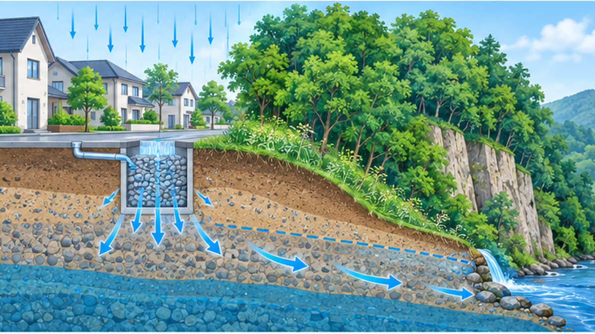
The spread of rainwater infiltration basins and permeable pavement doesn't just protect springs and groundwater — it also functions as a disaster-prevention measure, easing the concentration of rainwater rushing into rivers over a short period and curbing urban flooding. Spring conservation and disaster prevention are connected by the same underlying idea: letting rainwater return to the ground slowly.
The Ecosystems and Culture Springs Nurture
Springs are more than just a water resource — they are deeply intertwined with distinctive ecosystems and with Japanese life and faith.
The distinctive ecosystems springs create
Groundwater temperature at the same point in the same aquifer stays nearly constant, generally settling around 15–18°C year-round in Japan's plains (the Kakita River's water temperature likewise stays at about 15°C throughout the year). This stable temperature provides a comfortable environment through both summer and winter for cold-water-loving fish such as char (whose preferred temperature range is roughly 10–15°C), firefly larvae, and aquatic plants such as Japanese water crowfoot. Many "100 Best Springs" sites are also valued as habitats for these rare creatures.
Because springs stay cold in summer and never freeze in winter, their temperature fluctuates far less than that of surrounding rivers and ponds, allowing them to serve as a year-round "refuge" for certain aquatic organisms. At cooler springs like the Yotei Fukidashi Spring, where the water temperature drops to around 6.5°C, cold-water species that prefer even lower temperatures can thrive — showing how differences in water temperature from one spring to another shape the unique character of the ecosystem living there.
Springs, faith, and festivals
Places where clear water continuously rises have long been regarded as sacred, with shrines built at water sources and connections drawn to dragon-deity worship. Oshino Hakkai's role as a site of purification before climbing Mt. Fuji is one such example. For more on the history of communities protecting their water sources, see Shrines of Spring Water and Dragon-Deity Worship: The Local Codes That Protected Water Sources.
The connection to water-source forests
What stabilizes a spring's water volume is the forest upstream. For more on how forest soil temporarily stores rainwater and slowly releases it as groundwater, see What Water-Source Forests Do: How Forests Store Rain and Release It to Rivers, and the Reality Behind the "Green Dam" Theory. Protecting a spring and protecting the forest that feeds it are two sides of the same coin.
What We Can Do to Pass Springs On to the Future
Protecting springs isn't a job for local governments alone — it's also connected to how each of us lives day to day.
Rainwater infiltration basins and permeable pavement
If you live in a detached house, installing a rainwater infiltration basin on your property lets rainwater from your roof and yard soak into the ground, contributing to groundwater recharge. Some local governments offer subsidies for installation costs, so it's worth checking your municipality's environmental affairs website. Replacing driveway or garden paving with permeable materials or bricks instead of water-resistant concrete is another accessible option with the same effect.
The value of visiting and learning about famous springs
Actually visiting one of the "100 Best Springs" or a spring near you is more than just sightseeing. Learning where that water comes from and what protects it can spark interest in, and participation in, local conservation activities. If you encounter a spring while traveling, try reading the water quality panels or informational signs and paying attention to the local terrain and geology — the mechanisms described in this article should start to overlap with the landscape in front of you.
How water conservation protects groundwater
Groundwater is a resource that "decreases when pumped, and takes years to decades to return." Everyday water conservation helps prevent declining groundwater levels, which in turn helps protect springs. In areas where groundwater serves as the source of the public water supply, household water conservation translates directly into protecting the local spring environment.
Conclusion
Japan's "100 Best Springs" is not merely a list of "delicious water" — it is a program that evaluates both the natural phenomenon of springs, born of terrain and geology, and the community efforts that have kept protecting them. A spring is a water resource that only comes into being when an aquifer, a hydraulic head difference, and terrain all align — and that is anything but ordinary. As shown by the Kakita River's roughly 15°C and the Yotei Fukidashi Spring's roughly 6.5°C, even springs sharing the label "meisui" (famous water) differ in temperature and discharge depending on the terrain and climate of the land they come from, and each has become tied to the history and faith of its own region.
Key points of this article
- The "100 Best Springs" program evaluates community conservation activities, not just water quality
- A spring forms where an aquifer's water table meets the surface at a specific terrain feature
- Spring origins differ by terrain type: fan toes, escarpments, and volcanic foothills each produce different characteristics
- Increasing pavement from urbanization has driven the disappearance of springs
- Ordinances, community activities, and individual rainwater infiltration efforts are what will carry springs into the future
The next time you have the chance to visit a nearby spring or one of the "100 Best Springs," take a moment to reflect on the decades-long journey that water has traveled, and on the people who have worked to protect it.
References and Sources
- Ministry of the Environment, Japan – 100 Best Springs
- Tokyo Metropolitan Government Bureau of Environment – Current State of Tokyo's Springs
- Tokyo Metropolitan Government Bureau of Environment – Number of Spring Sites by Municipality
- Tokyo Metropolitan Government Bureau of Environment – Tokyo's Topography, Geology, and Groundwater
- Tokyo Metropolitan Government Bureau of Environment – Tokyo's 57 Notable Springs
- Numazu River and National Highway Office, Chubu Regional Development Bureau, MLIT – The Nature of the Kakita River
- Kokubunji City – Spring and Groundwater Conservation Ordinance
- Center for Integrated Research and Education of Natural Hazards, Shizuoka University – The Kakita River and Mishima Spring Cluster
- Japanese Association of Groundwater Hydrology – Is Groundwater Temperature Nearly Constant?
- Ministry of the Environment, Japan – 100 Best Springs: Yotei Fukidashi Spring
- Ministry of the Environment, Japan – 100 Best Springs: Nunobiki Ravine
- Ministry of Land, Infrastructure, Transport and Tourism – Water Resources: The State of Groundwater Conservation and Land Subsidence
※ Listed in order of reliability: government and academic institutions > peer-reviewed papers > specialized organizations > trusted media