⚡ In short
Forest and sea are linked by rivers. From the 1989 tree planting of the "Forest Is the Sea's Lover" movement to fulvic-acid iron, sediment cut by dams and nutrients carried by salmon, we explain watershed connectivity.
To protect the sea, you cannot look only at the sea.The whole route that rain takes—falling on mountains, running down rivers, and reaching the ocean—shapes the richness of coastal waters.
In 1989, fishers in Kesennuma raised the slogan "The Forest Is the Sea's Lover" and began planting trees on Mt. Murone, upstream of the river. That rule of thumb is now an important viewpoint for thinking about watershed connectivity.
Focusing on four flows—nutrients, iron, sediment and living things—this article explains the links between forest, river and sea, and efforts to restore them.
What you will learn
- The watershed concept and the four flows linking forest, river and sea
- How fulvic-acid iron and nutrients support coastal productivity
- The history and background of the "Forest Is the Sea's Lover" movement
- How dams, weirs and revetments affect sediment and animal movement
- Nutrients carried "from sea to mountain" by salmon and others
- Concrete actions in daily life to protect the watershed
Understanding the watershed as one connected ecosystem
What is a watershed? The area where rainwater gathers
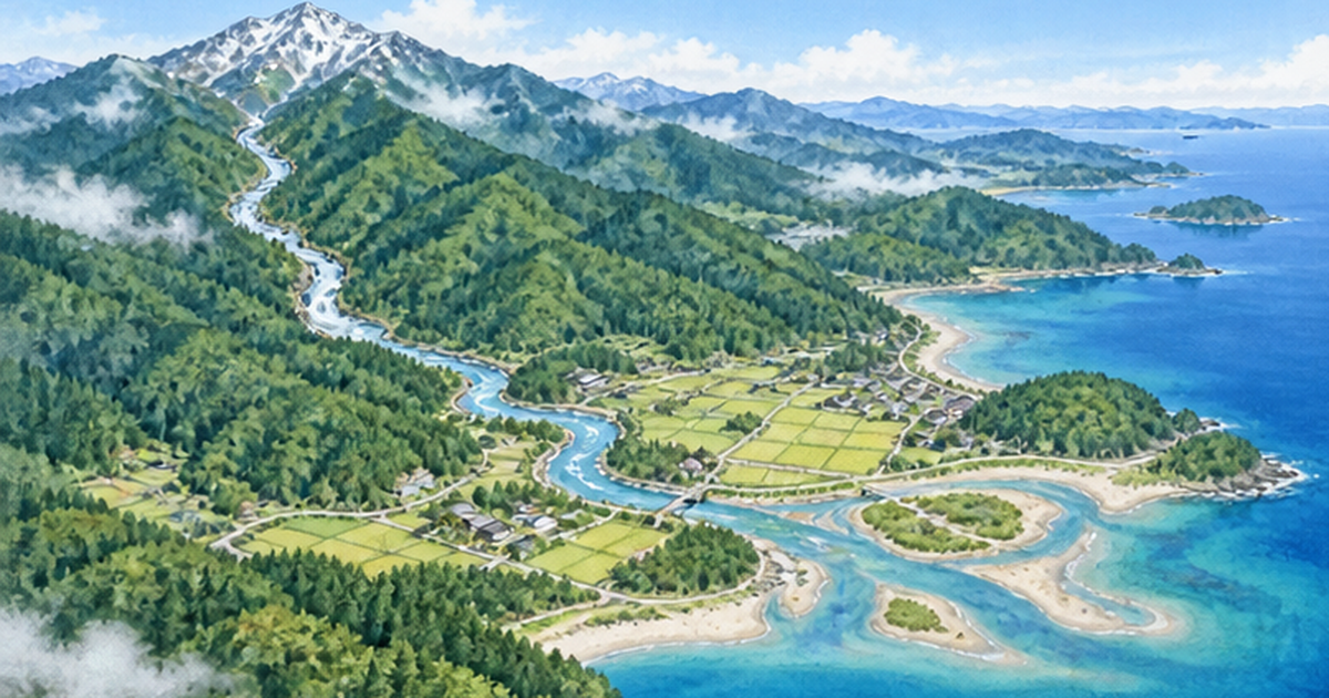
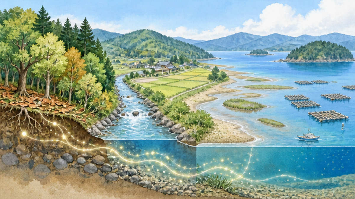
A watershed is the area from which rain falling at a given point gathers into a river by gravity. Mountain ridges form the boundary, and all rain falling inside a ridge flows through the same river and finally reaches the sea at the same river mouth. A watershed therefore forms a single "unit connected by water" that includes forests, fields, towns, rivers, tidal flats and the coastal sea. About two-thirds of Japan is forest, and rivers drop from steep mountains to the sea over short distances, so forest and sea are close and conditions on land readily affect the sea.
We usually think of forest, river and sea as separate. In an ecosystem, however, water works as a "transport route" that carries nutrients, sediment, fallen leaves and even living things. Events on land reach the sea through rivers, and part of the sea's bounty travels back up rivers to land. Understanding this two-way connection is the starting point for protecting the sea.
Key points of this section
- Watershed = the area where rainwater gathers into one river; forest, village, river and sea are one
- Water is a transport route for nutrients, sediment, fallen leaves and living things
- Connections run not only "mountain to sea" but also "sea to mountain"
Four flows that carry the connections
- Water flow: rain, groundwater, river water, coastal springs
- Material flow: nutrients such as nitrogen, phosphorus, iron and silicon, and organic matter
- Sediment flow: soil eroded from mountains travels down rivers and forms beaches and tidal flats
- Flow of living things: animals moving between river and sea, such as salmon, ayu, eels and mitten crabs
If any of these four flows is cut, the balance of the whole watershed breaks down. The following sections look at how each flow supports marine productivity and where human activity has interrupted it.
Nutrients and iron: how forests feed marine plankton
Nutrients that support marine production
Phytoplankton and seaweed need nutrients such as nitrogen, phosphorus and silicon. Much of this is supplied from land to the coast through river water and groundwater, which is one reason estuaries and inner bays are highly productive. Too much supply causes eutrophication, leading to red tides and oxygen-poor waters; too little leads to poor harvests such as faded nori seaweed. What matters is the "right amount and quality."
Iron: needed only in small amounts, yet essential
Another key element is iron. Iron is essential for phytoplankton photosynthesis, but in seawater it oxidizes and sinks easily, making it hard to use. The activities of Shigeatsu Hatakeyama and fellow oyster farmers in Kesennuma, Miyagi Prefecture, focused on this point. Humus formed from decomposing leaves of deciduous broadleaf trees yields a substance called fulvic acid; "fulvic-acid iron," formed when it binds with iron, is said to stay dissolved in seawater and be easy for phytoplankton to use.
In short, a rich broadleaf forest builds abundant humus, its benefits travel down the river to the bay, and the phytoplankton that feed oysters and scallops grow. Note, however, that iron also arrives by other routes such as Asian dust in the atmosphere and seafloor seepage, so the same mechanism does not apply equally to every sea area.
| Nutrient | Main role | Main route from land |
|---|---|---|
| Nitrogen, phosphorus | Basis of growth for phytoplankton and seaweed | River water, groundwater, rainfall, domestic and agricultural wastewater |
| Silicon | Material for diatom shells | Rock weathering, river water |
| Iron | Trace element needed for photosynthesis | Humus (fulvic-acid iron), soil particles, atmosphere (Asian dust) |
Source and note
For the balance of nutrients, see Where do nitrogen and phosphorus come from? for details.
Why fallen leaves and humus work "slowly"
Forest soil holds water like a sponge and releases it slowly to rivers. Fallen leaves and branches are decomposed gradually by microbes, and nutrients dissolve little by little. This "slow delivery" softens sudden changes in concentration and creates a stable environment for river and sea life. For the water-storing role of forests, see What are headwater conservation forests? as well.
The Forest Is the Sea's Lover: a movement born in Kesennuma oyster farming
1989: the tree-planting festival on Mt. Murone
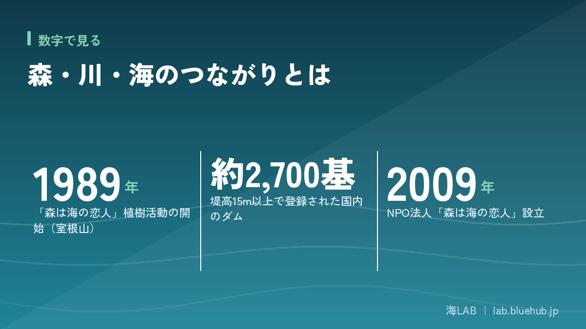
"The Forest Is the Sea's Lover" is the slogan of a tree-planting campaign that began in 1989. Upstream of the Okawa River, which flows into Kesennuma Bay, fishers began planting broadleaf trees on Mt. Murone in Iwate Prefecture. The slogan is said to have been proposed by local poet Ryuko Kumagai. The idea of seafaring fishers planting trees on mountains was strikingly new at the time and helped spread the watershed view that "to enrich the sea, first enrich the forest upstream."
The activity continued, and in 2009 the NPO "Mori wa Umi no Koibito" was established. The rule of thumb born in Kesennuma oyster farming later developed, through cooperation with researchers, into an academic field called "Forest-River-Sea Connectivity Science."
What became visible after the Great East Japan Earthquake
In the 2011 Great East Japan Earthquake, Kesennuma's oyster farms were also severely damaged by the tsunami. Even so, activities that value the connection of forest, river and sea drew renewed attention during recovery. Together with debates on seawalls and revetments, the idea that "to restore the sea you cannot look only at the sea" asked society to view the natural environment across the whole watershed.
Philosophy in brief
- Fishers plant trees on mountains—seeing the forest as an extension of work at sea
- The rule of thumb that broadleaf humus supports river and sea productivity
- Natural connectivity was reinterpreted through local people's lives and industries
Meeting researchers: Forest-River-Sea Connectivity Science
Researchers at Kyoto University added scientific backing to what fishers had felt. Forest-River-Sea Connectivity Science is a field that integrates the study of forest (mountain), village (human life) and sea (coast), and has developed across forest science, river engineering, fisheries science and social science. The meeting of fishers' experience with researchers' observation and analysis is a good example of locally rooted science.
What "The Forest Is the Sea's Lover" showed is that, even without special scientific knowledge, people who carefully watch the sea year after year are the first to notice changes in nature. For those of us learning about the sea, observing nearby rivers and forests is an important entry point.
Sediment and beaches: flows cut by dams and revetments
Rivers carry not only water but sand
Rivers carry sediment, produced by erosion of upstream mountains, gradually downstream and build beaches and tidal flats at river mouths and coasts. If this flow stagnates, the supply of sand to the coast falls short even as waves erode it, and beaches retreat. Behind thinning beaches across Japan are several overlapping factors, including sediment trapped by dams and erosion-control facilities, gravel extraction from rivers, and changes in longshore drift caused by coastal structures.
For the effects of dams and sediment replenishment efforts, see What is the relationship between dams and coastal erosion?, which covers them in detail. Here we summarize the key points from a watershed perspective.
The scale of dams in Japan
According to the Ministry of Land, Infrastructure, Transport and Tourism's Dam Handbook and similar sources, about 2,700 structures nationwide are registered as "dams" with a height of 15 m or more. In addition, there are enormous numbers of structures crossing rivers, such as low weirs, erosion-control dams and agricultural intake weirs. All play important roles in flood control, hydropower, water use and sediment-disaster prevention, but they also break the continuity of rivers.
| Structure | Main purpose | Effect on watershed connectivity |
|---|---|---|
| Dam | Flood control, water use, power generation | Traps sediment and nutrients; cuts fish movement |
| Weir (intake weir, estuary barrage) | Water intake, preventing saltwater intrusion | Hinders fish moving up and down; alters brackish zones |
| Erosion-control dam | Preventing sediment disasters | Less sediment supplied downstream |
| Three-sided concrete revetment | Safe flow of floodwater | Loss of riverbank vegetation and habitat |
The answer is not "zero" but "let it through"
In recent years, efforts to "let sediment through" have advanced in many places, such as sediment replenishment that sends sediment trapped in dams downstream, sediment bypass tunnels, and slit-type erosion-control dams. They aim to restore the watershed's material cycle while maintaining flood-control and water-use functions. Verifying effects takes a long time, but the viewpoint is shifting toward management that assumes watershed continuity.
Animals that travel between river and sea
Migratory fish as living transporters
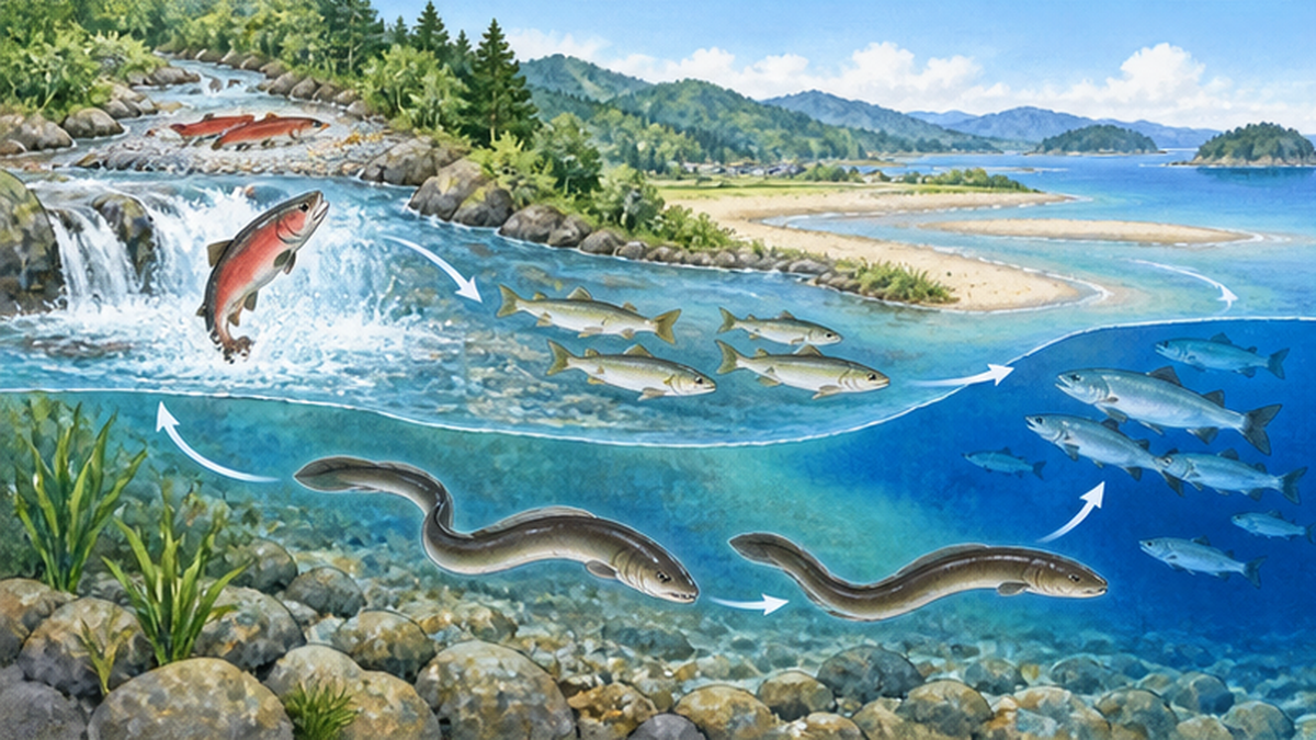
Fish that travel between river and sea embody the connections of a watershed. Salmon and trout are born in rivers, grow in the sea and return to their natal river to spawn—"anadromous" fish. Ayu (sweetfish) are born in rivers, spend their juvenile stage in the sea and migrate up rivers in spring. Japanese eels are born in the sea, grow in rivers and estuaries, and head back to sea to spawn—"catadromous" fish. Many other animals, such as mitten crabs, freshwater prawns and gobies, also use both river and sea during their lives.
For these animals a river is not a mere waterway but a "road" essential to their life history. If the road is cut, a species loses chances to breed and grow even when the upstream environment is good.
Fishways alone are not the answer
Weirs and dams across rivers sometimes have fishways so that fish can move up and down. Since fiscal 1998 the Ministry of Land, Infrastructure, Transport and Tourism has surveyed the upstream migration of ayu and other fish at fishways on river-crossing structures in directly managed sections. However, fishways mainly assume upstream movement, and consideration of downstream movement is often said to be insufficient. Cases of eel and ayu larvae being drawn into intakes and turbines have also been reported.
Points to note
Installing a fishway is a step forward, but the species, flow and seasons it serves are limited. "Having a fishway" does not necessarily mean "connected"; measures for downstream passage and securing flow must be considered together.
The decline of eels and the "living river"
The Japanese eel is classified as an endangered species on the IUCN Red List. Its decline is thought to stem from combined factors such as changes in the marine environment, overfishing and degraded river and estuary habitat. Restoring river continuity and riverbank environments also directly protects eel nursery habitat.
From sea to mountain: the "reverse flow" of nutrients carried by salmon
Spawning salmon and marine-derived nitrogen
Nutrients do not only flow one way from forest to sea. Salmon and trout swim up rivers carrying nutrients stored at sea and die after spawning. Their carcasses become food for bears, foxes, birds and aquatic insects, and the decomposed nutrients are also taken up by riverside plants. In salmon-run rivers on Hokkaido's Oshima Peninsula, analysis of nitrogen stable isotopes in willow leaves has reported that marine-derived nitrogen is used in the stretches the salmon reach.
Research on this "nutrient transport from sea to mountain" was first advanced on North America's Pacific coast, but it is also progressing in Japan. Whether salmon return to a river is also linked to the health of the riverside forest.
Two-way connection
- Forest to sea: humus, iron and nutrients support coastal productivity
- Sea to forest: salmon runs carry marine nutrients to upstream ecosystems
- If either flow weakens, the whole cycle thins
The role of riparian forest
Riparian forests along both banks of a river play a major role at the boundary of river and land: they shade the water and prevent warming, supply fallen leaves and insects to the water, and provide hiding places for fish through fallen trees. Losing riparian forest changes the river's food web and increases sediment inflow. For riverside forests, see also What is the role of riparian forest?.
Estuaries, tidal flats and bays: what happens at the "exit" of the connection
Estuaries: a crossroads of nutrients and life
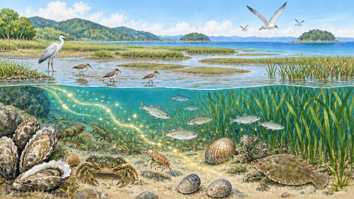
The estuary, where river meets sea, becomes a brackish zone mixing fresh and salt water; it is rich in nutrients and functions as a nursery for juvenile fish, crustaceans and shellfish. Shallow-sea ecosystems such as tidal flats, seagrass beds and mangroves are both "filters" and "cradles" that receive organic matter and nutrients from land, purify them and turn them into production. For how brackish zones work, see Estuary and brackish-water ecosystems.
Signs that the connection has been broken
| Phenomenon observed | Possible watershed-side background |
|---|---|
| Faded nori, nutrient shortage | Nutrients trapped upstream, variation in rainfall |
| Red tides, oxygen-poor water masses | Excess inflow of nitrogen and phosphorus, stagnant water |
| Beach retreat | Reduced sediment supply, coastal structures |
| Decline in juvenile and migratory fish | Estuary barrages, inadequate fishways, degraded river environment |
What matters here is not to pin the cause on a single factor. Factors outside the watershed, such as climate change, rising sea temperatures and fishing pressure, are also intricately involved. Watershed connectivity should be considered as "one important factor" together with others.
Efforts in Japan to restore the connection
Nature-oriented river works and restoring continuity
Since the 1990s Japan has reviewed concrete three-sided rivers and promoted "nature-oriented river works" that make use of natural topography and vegetation. Through restoring meanders, conserving riparian forest and improving fishways, these efforts aim to restore river continuity and diverse environments. For details, see What is nature-oriented river work?.
Satoumi and watershed management
In the Seto Inland Sea and elsewhere, the idea of "satoumi"—nurturing a rich sea by human hand—has spread, with seagrass bed and tidal flat restoration and nutrient management under way. A distinctive feature is linking these with watershed sewage treatment, farmland management and forest care, not just the sea. For the idea of satoumi, see What is satoumi?.
Positioning forest care as "for the sea"
Fisheries cooperatives and citizen groups around Japan are planting and thinning trees for the sea. The effects are hard to measure in the short term, but the activity of keeping forests healthy—soil water retention, supply of fallen leaves—itself contributes to the health of the whole watershed.
What recovery efforts have in common
- Think at the watershed scale, not at a single site
- Government, fishers, farmers, researchers and residents work together
- Keep monitoring, verify effects and improve
What we can do as members of a watershed
Small choices in daily life
As members of a watershed, our daily choices reach the sea through rivers. The basics are actions that reduce nutrient and waste loads: not pouring oil or leftover food down the drain, not overusing detergent, and applying fertilizer in proper amounts in gardens and farmland. Because plastic litter flows from towns through rivers to the sea, preventing littering is itself a marine-debris measure.
- Find out which watershed you live in and which sea the nearby river flows into
- Join local river observation events, clean-ups and tree-planting
- Choose local seafood and timber to support forest and sea industries
- Record and share changes you notice in rivers and the sea (fish species, water color)
As a subject of learning
A watershed is the best learning theme linking science, social studies, disaster prevention and industry. Check your town's position on a hazard map and walk from a river's source to its mouth, and you will feel how forest and sea, separate on a map, are connected as one by the flow of water.
Summary
- A watershed is one ecosystem in which forest, village, river and sea are connected by water
- Four flows—nutrients, iron, sediment and living things—support the sea's richness
- Dams and revetments bring benefits but also cut flows
- As with salmon runs, flows from sea back to mountain also exist
- Recovery needs watershed-scale cooperation and small choices in daily life
References and sources
- NPO Mori wa Umi no Koibito – Activity introduction
- Ministry of Land, Infrastructure, Transport and Tourism, Water Management and Land Conservation – Fish-friendly river works and river environment
- Japan Dam Foundation, Dam Handbook – Basic information on dams in Japan
- Kyoto University, Field Science Education and Research Center – Forest-River-Sea Connectivity Science
- Ministry of the Environment – Biodiversity and river and sea environments
- Fisheries Agency – Fisheries resources and inland-water fisheries
- IUCN Red List: Anguilla japonica – Assessment of the Japanese eel
* Ordered by reliability: government agencies and academic institutions > peer-reviewed papers > specialist organizations > reliable media