In recent years, phrases like "rain unlike anything we've experienced before" and "take action to protect your life" have become almost routine every time a typhoon approaches. Behind them lies a scientific reality: typhoons themselves are gradually turning into a different kind of creature. The key lies in the water temperature of the sea beneath our feet. Why does a warmer ocean make typhoons stronger?
According to the Japan Meteorological Agency (JMA), sea surface temperatures around Japan are rising at a rate of +1.36°C per century — about twice the global average of +0.63°C. In 2024, the annual average sea surface temperature around Japan reached its highest level since records began in 1908. A warm sea is a typhoon's "fuel tank" for staying on the move — and that tank is growing both larger and deeper.
This article walks through the basic mechanism by which typhoons form and intensify, the phenomenon of "rapid intensification" — in which a storm strengthens dramatically within 24 hours — the emergence of "super typhoons" with maximum wind speeds exceeding 67 m/s, and the coastal disaster-prevention challenges posed by linear precipitation bands and storm surges. Drawing on primary sources from the Ministry of the Environment, the JMA, JAMSTEC, and the IPCC, it is written to be accessible from middle-schoolers through adults.
What you'll learn in this article
- The basic mechanism by which typhoons draw energy — "latent heat" — from warm seas around 26.5°C and intensify
- How sea surface temperatures around Japan are rising at roughly twice the global average pace, warming even at depth
- Why "rapid intensification," in which central pressure drops by 40 hPa or more within 24 hours, is becoming more common
- How the intensification of typhoons connects to linear precipitation bands and heavy rain through increased atmospheric water vapor
- The coastal disaster risks from overlapping storm surge, high waves, and sea level rise, and the preparedness and decarbonization actions we can take
More Typhoons "Unlike Anything We've Experienced" — What Has Changed?
Records for heavy rainfall are broken almost every year, and regions that once rarely saw typhoons now suffer severe damage. Our shared sense that "typhoons have changed" is not just a matter of impression. Global warming has altered the state of the ocean and atmosphere, gradually pushing up both the "ceiling" of a typhoon's energy and the speed at which it develops.
Typhoons are nature's grand mechanism for redistributing the imbalance in solar energy the Earth receives — vast heat carriers that spiral heat accumulated in the warm seas of low latitudes toward higher latitudes. In that sense, typhoons are a phenomenon the planet actually needs. The problem is that the ocean, their energy source, is being warmed excessively by human activity. Typhoons themselves have always existed, but their "scale" and "behavior" are changing — that is the situation we now face.
The 2025 report "Climate Change in Japan 2025," published by the JMA, projects that globally, as global warming progresses, the proportion of intense tropical cyclones (typhoons) will increase, with high confidence. At the same time, the total number of typhoons is expected to "decrease or remain unchanged." In other words, the current scientific outlook is that while the number of typhoons won't rise, each individual storm is trending toward greater strength and heavier rainfall.
What Does "Getting Stronger" Actually Mean?
A typhoon's strength is expressed through its maximum wind speed near the center and its central pressure. Intensification mainly refers to three things happening at once, each tied to a different disaster-prevention risk.
- Maximum wind speed rises (greater damage from storm winds, high waves, and storm surge)
- Central pressure drops (the pressure "suction" effect raises storm surge levels)
- Rainfall associated with the typhoon increases (risk of flooding, landslides, and linear precipitation bands)
"Climate Change in Japan 2025" projects that under a climate in which global average temperature has risen 4°C above pre-industrial levels, rainfall over land in Japan associated with typhoons will increase. The fact that not just wind but also "rainfall volume" is increasing overlaps with the worsening severity of recent water-related disasters. From wind damage to buildings and power outages, to the expansion of the storm-force wind radius, to river flooding and landslides caused by record rainfall — the risks brought by typhoons are wide-ranging, and each one is being amplified by ocean warming.
In Japan, the common image used to be that typhoons "strengthen over the southern seas and weaken as they approach and make landfall in Japan." Because the sea grows colder further north and upper-level winds strengthen, disrupting a typhoon's structure, weakening as it approached was the norm. But ocean warming is gradually breaking down that premise of "arriving while weakening." There is growing concern that, going forward, more typhoons will retain their strength as they approach Japan, or even undergo rapid intensification very close to Japan.

Terms Used in This Article
- Typhoon: a tropical cyclone in the northwestern Pacific or South China Sea with maximum sustained wind speed near the center of roughly 17.2 m/s or higher
- Rapid intensification: a sharp strengthening in which central pressure drops by 40 hPa or more within 24 hours
- Super typhoon: a term for an extremely powerful tropical cyclone with maximum sustained wind speed near the surface exceeding 67 m/s (130 knots)
Ocean warming reaches our lives in many forms, including marine heatwaves and elevated water temperatures around Japan and impacts on fishery resources. Among these, the intensification of typhoons is a theme that concerns the largest number of human lives. Let's first look at how typhoons obtain their energy.
How Typhoons Form and Intensify — Latent Heat as the Engine
A typhoon is, at its core, a massive cluster of cumulonimbus clouds that developed over a warm sea. The engine spinning continuously at its heart is an invisible form of heat energy called "latent heat." The first key to understanding typhoon intensification is that the warmer the sea, the higher this engine's output.
26.5°C: The "Threshold for Formation"
For the tropical depression that becomes a typhoon to form, a general benchmark is a sea surface temperature of roughly 26.5-27°C or higher. When the sea surface is warm, seawater evaporates vigorously, supplying large amounts of water vapor to the lower atmosphere. This water vapor is precisely the "fuel" for a typhoon's engine.
Air containing water vapor is lighter, so it rises, and cools at altitude, turning into water droplets (clouds). During this process, as water vapor turns back into liquid, latent heat is released into the surrounding air. That released heat further warms the air, making it lighter and strengthening the updraft. The strengthened updraft lowers the pressure near the sea surface, drawing in even more moist air from the surroundings. In this way, a positive feedback loop (a self-reinforcing cycle) begins to spin: "water vapor supply → release of latent heat → strengthened updraft → drawing in even more water vapor."
- Large amounts of water vapor evaporate from the warm sea surface
- The moist air rises, forming cumulonimbus clouds
- As the water vapor condenses, it releases latent heat and warms the atmosphere
- The warmed atmosphere further strengthens the updraft and lowers the pressure
- More moist air flows in toward the lowered pressure

The Temperature Needed to Form Differs From the Temperature Needed to Intensify
Here is an important point: the water temperature required for a typhoon to "form" and the water temperature required for a typhoon that has already formed to "intensify further" are not the same. While the benchmark for formation is 26.5-27°C, a typhoon strengthening further is favored by a higher sea surface temperature, on the order of 28-30°C. As the ocean warms and areas of high sea surface temperature expand, the "arena" in which typhoons can develop expands with it.
The Typhoon's "Eye" and Eyewall — Markers of Strength
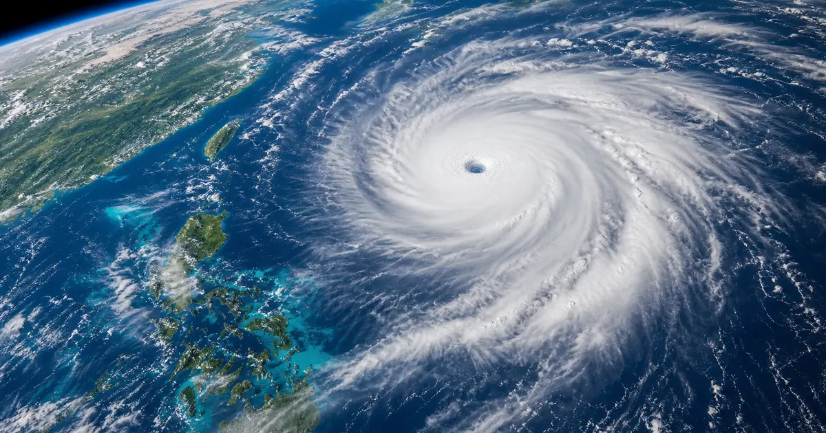
At the center of a developed typhoon forms an "eye" that is nearly cloud-free. The wall of the tallest cumulonimbus clouds surrounding the eye is the "eyewall," where the most intense updrafts and storm-force winds occur. The stronger a typhoon becomes, the more sharply defined and compact its eye grows, and the more developed its eyewall becomes. A typhoon whose "eye is clearly visible" in satellite imagery is considered dangerous precisely because that clarity is evidence of a well-developed structure. During rapid intensification, this eye and eyewall come together and tighten in a remarkably short span of time.
Conversely, when upper-level winds are strong, dry air flows in, or the storm encounters terrain or land, this structure breaks down and the typhoon weakens. In other words, a typhoon's strength is determined by a tug-of-war between "how much fuel it can get from the sea" and "how well it can maintain its structure." Because ocean warming works to unilaterally strengthen the former, it is creating an environment in which typhoons as a whole are more prone to intensify.
Key Point
A typhoon is a "heat engine" that strengthens itself by releasing latent heat, fueled by water vapor from a warm sea. The higher the sea surface temperature, the greater the fuel supply and the higher the engine's output. It is this simple but powerful physics that forms the foundation of typhoon intensification driven by ocean warming.
How the Sea Becomes a "Fuel Tank" — Rising Sea Surface Temperature and Ocean Heat Content
If a typhoon's fuel is the heat stored in the ocean, global warming is steadily enlarging that tank. And the problem isn't limited to the ocean's "surface." Whether the deeper layers of the ocean have also warmed is a hidden factor that determines whether a typhoon can rapidly intensify.
The Ocean Absorbs About 90% of the Excess Heat
According to the IPCC's (Intergovernmental Panel on Climate Change) Sixth Assessment Report, of the excess heat stored in the Earth's system due to global warming, the ocean has absorbed about 90%. The ocean has acted as an enormous "buffer" softening the rapid warming of the Earth's surface — but as a result, the ocean itself has steadily accumulated heat. JMA observations also show that the amount of heat stored in the ocean (ocean heat content) has continued to increase since the 1950s, with the pace of increase accelerating since the mid-1990s.
Waters Around Japan Are Warming at About Twice the Global Average
This warming is especially pronounced around Japan. According to the JMA, the annual average sea surface temperature around Japan is rising at a rate of +1.36°C per century, about twice the global average rate of +0.63°C. Furthermore, in 2024 the annual average sea surface temperature around Japan was +1.44°C above normal, the highest on record since observations began in 1908. The seas along the paths where typhoons travel northward have become warmer than ever before.
| Indicator | Value | Source / Notes |
|---|---|---|
| Rate of sea surface temperature rise around Japan | +1.36°C per century | JMA, Marine Diagnosis Tables |
| Global average rate of sea surface temperature rise | +0.63°C per century | JMA (waters around Japan warming at roughly twice this pace) |
| 2024 anomaly for waters around Japan | +1.44°C (highest since 1908) | JMA, interim diagnosis tables |
| Share of Earth's excess heat absorbed by the ocean | About 90% | IPCC Sixth Assessment Report |

"Depth" Is the Key to Rapid Intensification
A typhoon has the property of churning up the sea beneath it, dragging cold water from the depths up to the surface. In a sea where only the surface is warm and the water just below is already cold, the passage of a typhoon cools the surface and cuts off its fuel supply. But in a sea where warm water extends deep down, churning doesn't easily cool the surface, and a typhoon can intensify rapidly without running short of fuel. Warm ocean currents like the Kuroshio, and areas where marine heatwaves keep sea surface temperatures elevated for long periods, are exactly this kind of "deep fuel tank." Behind the strong development of Typhoon No. 10 south of Kagoshima in 2024, it has been pointed out that the Kuroshio kept both surface and subsurface water temperatures from dropping easily.
The indicator that captures this "depth" numerically is ocean heat content. Even with the same sea surface temperature, a sea with a thin warm layer and one with a thick warm layer differ enormously in the total energy they can supply to a typhoon. We often see maps of sea surface temperature in weather forecasts, but in predicting typhoon development, it is not just the surface temperature but "how deep that warmth extends" that is decisively important. The fact that the ocean's overall heat content is increasing due to global warming means that this hidden fuel reserve is steadily growing.
Connection to Marine Heatwaves
A "marine heatwave" — a period of abnormally high sea surface temperature — becomes a prime fuel-supply zone for typhoons. For the long-term impact of marine heatwaves on ecosystems, see also our companion article explaining marine heatwaves (the "Blob").
The mechanism behind marine heatwaves themselves and their actual state around Japan are covered in detail in Marine Heatwaves and Elevated Water Temperatures Around Japan, and the damage they cause to ecosystems, such as coral bleaching, is covered in The Long-Term Scars Marine Heatwaves Leave on Ecosystems. The intensification of typhoons shares the same underlying root with these phenomena — the ocean is being warmed too much.
Heat Stored in the Ocean Doesn't Disappear Easily
What makes ocean heat content troublesome is that once heat has accumulated, it is very slow to dissipate. The ocean can store far more heat than the atmosphere, and that heat is carried slowly down into deeper layers. Even if greenhouse gas emissions were to stop right now, the ocean's warmed state is expected to persist for some time. In other words, we have already reached a stage where we must coexist with typhoons on the premise of an already-warmed ocean. That is precisely why both efforts not to warm the sea further (mitigation) and preparedness to protect lives under an already-warmed ocean (adaptation) are needed.
The rate of increase in the annual mean sea surface temperature averaged over the waters around Japan through 2025 is +1.36°C per century, greater than the rate of increase in the global mean sea surface temperature (+0.63°C).
— Japan Meteorological Agency, Marine Diagnosis Tables
What Is Rapid Intensification?
A phenomenon that has drawn particular concern with recent typhoons is what's called "rapid intensification" or "rapid strengthening." Rather than strengthening gradually over several days, a storm can transform into something else entirely in roughly a single day, creating the serious problem that evacuation preparations cannot keep up.
A Sudden Shift: 40 hPa or More in 24 Hours
There are several research definitions of rapid intensification, but in Japan it often refers to a sharp intensification in which central pressure drops by 40 hPa or more within 24 hours. Since a typhoon strengthens as its central pressure drops, this means the storm-force wind radius can expand dramatically and wind speeds can jump within a single day. A storm forecast as a "strong typhoon" the previous day could become a "violent typhoon" by the next morning.
This "time lag" is the single biggest reason rapid intensification poses such a challenge for disaster prevention. It takes a certain amount of time for people to prepare to evacuate and actually move to a safe location. Yet a rapidly intensifying typhoon raises its danger level in a short span of time, as if stealing away that preparation time. While people are thinking "we should still be okay," they may find, almost without realizing it, that conditions outside have become too violent to step out into — an era of rapid intensification demands that we make decisions one step earlier to avoid exactly this kind of situation.
Conditions That Bring About Rapid Intensification
Rapid intensification is not determined by sea surface temperature alone. It is thought to occur most readily when the following favorable conditions align. Ocean warming appears to be raising the likelihood of rapid intensification particularly by boosting "a warm sea and abundant water vapor."
- Sea surface temperature is high, with warm water extending deep down (large ocean heat content)
- Upper-level winds (vertical wind shear) are weak, so the typhoon's tall vertical structure is not easily disrupted
- Strong "outflow" — air being expelled outward at high altitude
- The mid-level atmosphere is moist, so the storm's momentum is not sapped by inflowing dry air

Lessons From the Reiwa 1 East Japan Typhoon (Typhoon No. 19)
A commonly cited example of rapid intensification is the 2019 Reiwa 1 East Japan Typhoon (Typhoon No. 19, internationally named Hagibis). This typhoon rapidly intensified while passing over waters warmer than normal, recording a drop in central pressure of 77 hPa within 24 hours. Just about 39 hours after forming, its central pressure had reached a violent-typhoon intensity of 915 hPa. Although it had weakened to 955 hPa just before landfall, it brought record-breaking rainfall, with total precipitation reaching 1,000 mm at Hakone in Kanagawa Prefecture. The death toll exceeded 100 for the first time in 40 years since 1979, and more than 90,000 homes were damaged.
The typhoon rapidly intensified while passing through an area of higher-than-normal sea surface temperature, and at 18:00 on the 7th it recorded a pressure drop of 77 hPa over the preceding 24 hours.
— From records of the Reiwa 1 East Japan Typhoon by the Japan Meteorological Agency and the Cabinet Office
One reason this typhoon caused such massive damage across a wide area of Japan is that it approached Honshu without losing much strength, still carrying a large mass of water vapor built up during its rapid intensification over the warm southern seas. An intensified typhoon is itself a "moving reservoir" carrying enormous amounts of water vapor, and when it collides with terrain before and after landfall, it produces record-breaking rainfall. Rapid intensification not only raises the risk of storm-force winds, it is also closely tied to the risk of heavy rain.
The Challenge of Forecasting Difficulty
Rapid intensification is one of the phenomena that is difficult even for weather experts to forecast. The speed of intensification is determined by a complex interplay not just of sea surface temperature but also upper-level winds, moisture, and the fine internal structure of the typhoon, so it is not easy to pin down precisely "when" and "how suddenly" a storm will strengthen. In recent years, numerical forecast models and observation technology have improved accuracy, but it remains essential, as a basic stance for disaster prevention, to always keep in mind "the possibility of intensifying beyond the forecast" and to act early, anticipating the worst.
Why Rapid Intensification Is So Frightening
- Because it strengthens faster than forecasts, evacuation preparation and decisions can struggle to keep up
- If the peak of intensification comes just before landfall, storm-force winds and storm surge can strike the coast before the typhoon has weakened at all
- Stronger typhoons have a wider storm-force wind radius and heavier rainfall area, making widespread simultaneous damage more likely
The Rise of Super Typhoons and What Future Projections Show
The endpoint of intensification is the extremely powerful storm known as a "super typhoon." Japan has so far rarely been struck directly by a super typhoon, but it has been pointed out that as ocean warming progresses, that premise may collapse in the future.
What Is a Super Typhoon?
A super typhoon refers to a tropical cyclone whose maximum sustained wind speed near the surface exceeds 67 m/s (130 knots). Converted to speed, that's a storm-force wind exceeding roughly 240 km/h — comparable to a wind blowing continuously as fast as a bullet train. Typhoons that developed over lower-latitude seas such as near the Philippines or Taiwan have reached this intensity before, but as they moved north toward Japan, sea temperatures typically dropped and the storms weakened, which had long been the norm.
A Future Where Storms "Move North While Retaining Their Strength"
A research team including Nagoya University and the JMA's Meteorological Research Institute used high-resolution numerical simulations to project that, with global warming, the intensity of super typhoons will increase markedly by the end of the 21st century. The maximum intensity of the strongest super typhoons under a future climate could reach wind speeds of 85-90 m/s with a minimum central pressure of around 860 hPa. Even more concerning, the study showed that under future warmer seas, typhoons could move north while retaining their strength all the way into mid-latitude regions, including Japan. As the seas along northward tracks warm, fuel supply continues, making it harder for storms to weaken.
| Category | Approximate maximum wind speed | Notes |
|---|---|---|
| Violent typhoon (current strongest category) | 54 m/s or higher | JMA classification |
| Super typhoon | Above 67 m/s (130 knots) | Term used by the US Joint Typhoon Warning Center and others |
| Strongest projected class under future climate | 85-90 m/s / around 860 hPa | Simulation by Nagoya University, the Meteorological Research Institute, and others |

Changes We Can Be Confident About, and Parts That Remain Uncertain
The IPCC and "Climate Change in Japan 2025" express high confidence in both an increase in the proportion of intense typhoons and an increase in typhoon-associated rainfall. On the other hand, uncertainty remains regarding how the total number of typhoons will change and how the tracks of individual storms will evolve. From a disaster-prevention standpoint, the practical takeaway is: "regardless of the number, the power of the ones that do hit is increasing."
If a super typhoon were to strike a densely populated area of Japan while retaining its intensity, the resulting damage could be on an entirely different scale from any typhoon we have experienced before. Storm-force winds exceeding 240 km/h can topple utility poles and signs, tear off roofs, and turn flying debris into deadly projectiles. Widespread window breakage, extensive and prolonged power outages, and a complete paralysis of transportation and logistics are all conceivable. The reason researchers are mapping out this future through precise simulations is so that society can prepare in advance for such worst-case scenarios. Future projections are not a "scare tactic" — they are a "map" for preparation.
Indeed, in 2025 the total number of typhoons formed was somewhat below the average year, yet specialist agencies have warned that "even in a year with fewer typhoons, a storm can still become extremely violent if it develops over high sea surface temperatures." A projection in which the total number of typhoons decreases while the proportion of intense storms rises shows that the most dangerous complacency is thinking "there are few typhoons this year, so we're safe." What matters is not the count, but paying attention to the potential power of each individual storm.
A Common Misconception
It's often assumed that "warming will increase the number of typhoons," but scientific projections actually suggest the number will decrease or stay flat. What's increasing is "the proportion of intense typhoons" and "the amount of rainfall." Don't let a low count lull you into complacency — it's important to remain vigilant about each individual storm.
The Link to Linear Precipitation Bands — An Atmosphere Loaded With More Water Vapor
Alongside the intensification of typhoons, "linear precipitation bands" are another factor deepening the severity of recent water-related disasters. Even when a typhoon's center does not make a direct hit, the moist air a typhoon brings can trigger prolonged, localized torrential rain. What connects the two is the increased atmospheric water vapor caused by warming.
What Is a Linear Precipitation Band?
A linear precipitation band is a group of cumulonimbus clouds that form one after another and organize into a line-shaped formation. The JMA explains the mechanism behind their formation roughly as follows. A single cumulonimbus cloud normally dissipates in about 30 to 60 minutes, but because new cumulonimbus clouds keep forming in the same location, intense rain continues to fall over the same area for an extended period.
- A sustained inflow of warm, moist air continues, mainly in the lower atmosphere
- That air is lifted by a local front or terrain, generating rain clouds
- Under unstable atmospheric conditions, the rain clouds develop into cumulonimbus clouds, forming multiple clusters
- Upper-level winds cause the cumulonimbus clusters to line up, forming a linear precipitation band
The Mechanism Called "Back-Building"
A representative mechanism that sustains a linear precipitation band for a long time is what's known as the "back-building" type. Cumulonimbus clouds form one after another on the upwind side of the same location and are then carried downwind, forming a line, so rain clouds keep passing continuously over the same region on the ground without a break. The result is torrential rain concentrated in a narrow area, causing river flooding and landslides. Because intense rain continues over the same location for hours, rivers can overflow and mountain slopes can collapse within a short time, and the danger level rises so rapidly that there is often almost no time left to escape.

The Connection to Global Warming
Warmer air can hold more water vapor (saturated water vapor content increases by roughly 7% for every 1°C rise in temperature). As sea surface temperature rises, evaporation from the ocean increases, and warmer air is able to carry more water vapor — increasing the "raw material" for linear precipitation bands and typhoon rainfall alike. The chain in which a typhoon carries a large volume of moist air up from the south, which is then lifted by terrain or a front and turns into torrential rain, can only occur because of a warm sea and moist atmosphere. Much about the conditions for linear precipitation band formation remains unresolved and difficult to forecast, but the broad trend of increasing "raw material" for rain is certain.
In recent years, when the JMA judges that the danger from heavy rain caused by a linear precipitation band is rapidly escalating, it issues "meteorological information on remarkable heavy rain," and it is also working to provide forecast information roughly half a day in advance. Precisely because this is a phenomenon that is difficult to forecast, receiving information issued by authorities early and, if you sense danger, evacuating without fearing a false alarm, are the individual actions that protect lives.

Don't Let Your Guard Down Even If the Typhoon Itself Stays Away
Even when a typhoon is passing far away, moist air flowing in from it can trigger a linear precipitation band and cause record-breaking heavy rain in a distant region. It's important to pay attention not only to typhoon information but also to heavy rain and flood warnings and forecast information on "linear precipitation bands."
Impact on Coastal Disaster Prevention — Storm Surge, High Waves, and Sea Level Rise Combine
As an intensified typhoon approaches the coast, another serious threat closes in from the sea itself, in addition to wind and rain: storm surge and high waves. And because sea level rise is steadily raising the baseline, the risk of a "compound disaster" — in which multiple factors overlap — is growing.
Why Do Storm Surges Happen?
A storm surge is a phenomenon in which the sea level rises abnormally due to a typhoon or a developed low-pressure system, occurring mainly through two effects. The stronger a typhoon is (the lower its central pressure) and the stronger its winds, the higher the storm surge. In other words, the intensification of typhoons translates directly into an increase in storm surge risk.
- Suction effect: the lower the central pressure, the more the sea surface is lifted (sea level rises by roughly 1 cm for every 1 hPa drop in pressure)
- Wind setup effect: strong winds push seawater toward the coast, causing a large rise in water level, especially at the head of a bay
Damage is amplified further when a storm surge coincides with high tide. In areas below sea level, such as "zero-meter zones" where many people live on land lower than the sea, storm surge flooding can extend over a wide area and last for a long time. In Japan, population and assets are concentrated in the coastal areas of major cities such as Tokyo, Osaka, and Nagoya, so a large-scale storm surge could cause immeasurable economic damage. Historically, the 1959 Isewan Typhoon caused enormous loss of life from storm surge, and storm surge remains one of the greatest threats in Japan's coastal disaster prevention.

Sea Level Rise Raises the Baseline
The IPCC's Special Report on the Ocean and Cryosphere in a Changing Climate (SROCC) states it is likely that global mean sea level will rise by roughly 0.29-1.10 m by the end of the 21st century, relative to 1986-2005. Sea levels around Japan have also been trending upward since the 1980s. As the average sea level rises, even a typhoon of the same intensity will push a storm surge further inland and higher up. The IPCC's Sixth Assessment Report also points out that if sea level rise, storm surge, and river swelling from heavy rain occur simultaneously, coastal flood risk rises sharply.
For example, if river water levels are already elevated due to heavy rain, and a typhoon's storm surge then pushes water levels up from the sea side, river water becomes harder to discharge into the sea, and flooding becomes more likely further inland. This is called the "backwater phenomenon," and low-lying areas near river mouths require particular vigilance. A compound disaster in which wind, rain, and sea all bare their teeth at once cannot be adequately prepared for if each is considered in isolation. It is essential to understand, in normal times, in three dimensions, what risks — from the sea, rivers, or mountains — the place where you live is exposed to.
High Waves and Coastal Erosion
A strong typhoon also brings high waves. Some studies project that climate change will increase high waves along Japan's Pacific coast. High waves cause waves to overtop breakwaters and accelerate the erosion of sandy beaches, gradually eating away at coastal ecosystems and the foundations of people's livelihoods. In thinking about this coastal defensive capacity, attention is also turning to green infrastructure — disaster prevention that harnesses the power of nature, such as blue carbon ecosystems and tidal flat conservation. Healthy seagrass beds, tidal flats, and mangroves can serve as natural buffer zones that soften the energy of waves.
The JMA's "Climate Change in Japan 2025" and the Climate Change Adaptation Information Platform (A-PLAT) emphasize that, in response to this growing coastal disaster risk, it is important to accurately track change through sea level monitoring and climate projections, and to combine hard measures — such as levees and floodgates — with soft measures — such as evacuation planning, land use, and insurance — in an optimal way. Disaster prevention is not the job of government alone; it functions only once each resident knows and prepares for the risks in their own area.

The Compound-Disaster Perspective
Future coastal disaster prevention must treat storm-force winds, heavy rain, storm surge, high waves, and sea level rise not as "separate things," but prepare for them as a compound disaster that can overlap simultaneously. Combining hard measures (levees, floodgates) and soft measures (evacuation plans, hazard maps) optimally, and adapting them as conditions change, is considered essential.
What We Can Do — Both "Preparing" and "Reducing"
The intensification of typhoons is a planet-scale change, but there is still much individuals and communities can do. Broadly, there are two directions: "preparing" (adaptation) for an approaching typhoon, and "reducing" (mitigation) the root cause — global warming.
Adaptation: Preparedness to Protect Lives
In an era of rapid intensification, "acting early" is the best defense there is. Make your judgments with margin to spare, assuming that a storm's intensity may strengthen every time the forecast is updated. Especially in households with elderly family members, small children, or people with disabilities, it's important to anticipate that evacuation will take time and to be prepared to act even before a warning is issued.
- Check your home's or workplace's hazard map (flooding, storm surge, landslides) ahead of time, during normal periods
- Check forecasts of the typhoon's track and intensity frequently starting several days before it approaches, and prepare early and often
- If forecast information on a "linear precipitation band" or a heavy rain/storm surge warning is issued, move to evacuate without hesitation
- Keep an emergency go-bag, several days of supplies, and a way to charge your phone ready at all times
- In coastal and low-lying areas, be especially alert when high tide coincides with a storm surge warning
Mitigation: Choices That Keep the Sea From Overheating
At the root of typhoon intensification lies global warming driven by increased greenhouse gases. Reducing ocean warming, even slightly, requires decarbonization across society as a whole. Each individual choice adds up to become a real force. Reconsidering how we use energy and protecting the ocean's ecosystems, which absorb and store carbon dioxide, may seem like an indirect route, but they are connected to typhoon countermeasures. Curbing, even a little, the heat the ocean accumulates over the coming years is a long-term and fundamentally essential measure that will shape the strength of the typhoons the next generation must face.
You might feel that "there's no point in me alone saving electricity." But climate change is a problem born from the accumulation of countless small choices, and that is precisely why it can only be eased by countless small shifts in those choices. It is only when individual action, corporate decarbonization, and national policy all point in the same direction that the pace of ocean warming will finally slow. Rather than ending typhoon news with just "that's scary," turning our attention to the connection between our daily lives and the ocean is itself the first step toward change.
- Reduce the CO2 emitted by daily life through energy conservation and renewable energy use
- Protect and nurture blue carbon ecosystems (seagrass beds, tidal flats, mangroves) — the ocean's carbon sinks
- Prevent the outflow of plastic waste and fishing gear, and keep the ocean healthy

The problem of marine debris is covered in the article on ghost gear (abandoned fishing gear), and the relationship between warming and coral is covered in the mechanism of coral bleaching. Typhoons, marine heatwaves, bleaching, and sea level rise are all different manifestations of a single underlying trend: the ocean is being warmed too much. Seeing these as connected, rather than looking at any one in isolation, is the first step toward facing the ocean going forward.
A Small Step You Can Take Today
- Open your area's hazard map together with your family and check your evacuation destination and route
- Before typhoon season, inspect and refresh your emergency supplies and go-bag
- Reconsider your electricity contract and usage, and take part in decarbonization within a comfortable range
- Take an interest in ocean environmental news and share it with the people around you
Conclusion — A Warmer Sea and Stronger Typhoons
Ocean warming is making a typhoon's "fuel tank" both larger and deeper. A sea that has warmed not just at the surface but down into its depths is pushing typhoons toward rapid intensification and setting the stage for storms to move north while retaining their strength. Even without an increase in number, each individual storm growing stronger and bringing more rain — that is the picture of typhoons current science presents.
At the same time, heavy rain from linear precipitation bands, storm surge, high waves, and steadily advancing sea level rise are overlapping, and coastal disaster prevention is being asked, more than ever, to prepare for "compound disasters." But we are not powerless. Adaptation through early evacuation, and mitigation through decarbonization to keep the sea from overheating further — keeping both of these wheels turning is the key to surviving an era of stronger typhoons.
Understanding the relationship between the ocean and typhoons is by no means a topic reserved only for distant experts. The next time you watch a typhoon's track, take a moment to think about how much the sea beneath it has warmed. Marine heatwaves, coral bleaching, changes in fishery resources, and the intensification of typhoons — all of these are different faces of a single change in the ocean. Knowing the ocean and protecting the ocean are, in truth, connected to protecting our own lives and livelihoods.
Summary of This Article
- Typhoons intensify using water vapor (latent heat) from warm seas as their engine, and tend to strengthen further as sea surface temperature rises
- Sea surface temperature around Japan has risen +1.36°C over a century, about twice the global average, and 2024 set a new record high
- A sea where warm water extends deep down promotes "rapid intensification," a drop of 40 hPa or more within 24 hours
- In the future, super typhoons (exceeding 67 m/s) may move north toward Japan while retaining their strength
- Typhoon intensification overlaps with heavy rain from linear precipitation bands, storm surge, and sea level rise, raising the risk of compound disasters
- Prepare for stronger typhoons through both "early evacuation" (adaptation) and "decarbonization and ocean conservation" (mitigation)
References and Sources
- Japan Meteorological Agency - Marine Diagnosis Tables: Long-term trend of sea surface temperature (waters around Japan)
- Japan Meteorological Agency - Climate Change in Japan 2025 — Observation and Projection Assessment Report on the Atmosphere, Land, and Ocean —
- Japan Meteorological Agency - On phenomena that are difficult to forecast (heavy rain from linear precipitation bands)
- Japan Meteorological Agency - Knowledge of Tides and Sea Level: Storm Surge
- Cabinet Office, Disaster Prevention Information Page - On the Damage Caused by Typhoon No. 19 of Reiwa 1
- National Institute for Environmental Studies, Environmental Outlook Platform - Nagoya University and Others Announce Increase in Super Typhoon Intensity Due to Global Warming
- JAMSTEC - Kuroshio-Oyashio Watch: Recent Marine Heatwaves and Cold Spells (Marine Heatwaves and Typhoons)
- Climate Change Adaptation Information Platform (A-PLAT) - Storm Surge and High Waves: Natural Disaster and Coastal Zone Field
- Japan Meteorological Agency - Marine Diagnosis Tables: Long-term trend of ocean heat content (global)
* Listed in order of reliability: government and academic institutions > peer-reviewed papers > specialist organizations > trusted media