⚡ In short
Why are forests called "green dams"? Natural forest infiltration of 412 mm/h, rainfall that takes 2.1 to 8.0 years to emerge as stream water, 9.28 million hectares of water-source protection forest — using primary data from Japan's Forestry Agency and Forest Research Institute, this article sets out how forests store water, why they cannot stop the largest floods, and how the forest reaches all the way to the sea.
Turn the tap and water comes out. Follow that water upstream and you almost always end up in a mountain forest. About two-thirds of Japan's land area is forested, and 9.28 million hectares of it is designated as "water-source protection forest" — 71.1% of all protection forest, by far the largest category (Forestry Agency, as of 31 March 2025). Japan's forest policy is, in other words, less about harvesting timber than about protecting forests in order to protect water.
This function is now widely called the "green dam", sometimes described as though it could substitute for concrete. Forest hydrologists are more cautious: "Excessive expectations of the water-holding capacity of forests carry large risks in the face of the concentrated downpours and typhoons brought by extreme weather," warns Motohisa Fujieda of the Forest Research and Management Organization. Forests store water. But they are not omnipotent. Holding both truths at once is where any serious discussion of headwater forests has to begin.
This article draws on primary sources — the Forestry Agency's Technical Guide to the Water Source Recharge Function of Forests (March 2023), the Science Council of Japan's 2001 report, and field measurements from the Forest Research Institute and the Hokkaido Research Organization — to work through four questions in turn: how forests store rain, how large the effect is and where its limits lie, what goes wrong in under-managed plantations, and how headwater forests connect to the richness of the sea.
What you will learn
- What the water source recharge function actually is — flood mitigation, water storage and purification, set out from the official definition
- How rain passes through canopy, litter layer, soil and bedrock on its way to the river, and on what timescales
- What the water-holding capacity and infiltration of forest soil measure in practice, in millimetres, from Japanese field data
- Where the "green dam" works and where it stops working — separating genuine effect from overreach
- The evapotranspiration paradox: more forest does not necessarily mean more water in drought
- How headwater forests connect to coastal productivity, and which parts of that story are established and which are still hypothesis
What a Headwater Forest Is — and What Actually Holds the Water
A headwater forest is forest protected and managed for its ability to stabilise the flow and quality of rivers. The Japanese term kan'yō (涵養), usually translated as "recharge", carries the sense of nurturing something slowly, the way water seeps into ground of its own accord.
The official definition puts soil at the centre
The Science Council of Japan's report of November 2001 defines the function as follows: "Forests, chiefly through the action of forest soil, allow rainwater to infiltrate the ground and release it slowly. This moderates flood runoff and stabilises river discharge. Water flowing out of forests is also low in turbidity, moderately mineralised, and close to neutral in pH."
What deserves attention is that the subject of the sentence is not "the forest" but "the action of forest soil". What holds the water is not the trees themselves but the soil the trees have spent a long time building. That distinction is the key to reading the "green dam" debate correctly later in this article.
Forests, chiefly through the action of forest soil, allow rainwater to infiltrate the ground and release it slowly. This moderates flood runoff and stabilises river discharge.
― Science Council of Japan, report on "Evaluation of the Multifunctional Roles of Agriculture and Forests in Relation to the Global Environment and Human Life" (November 2001)
Three faces (officially four)
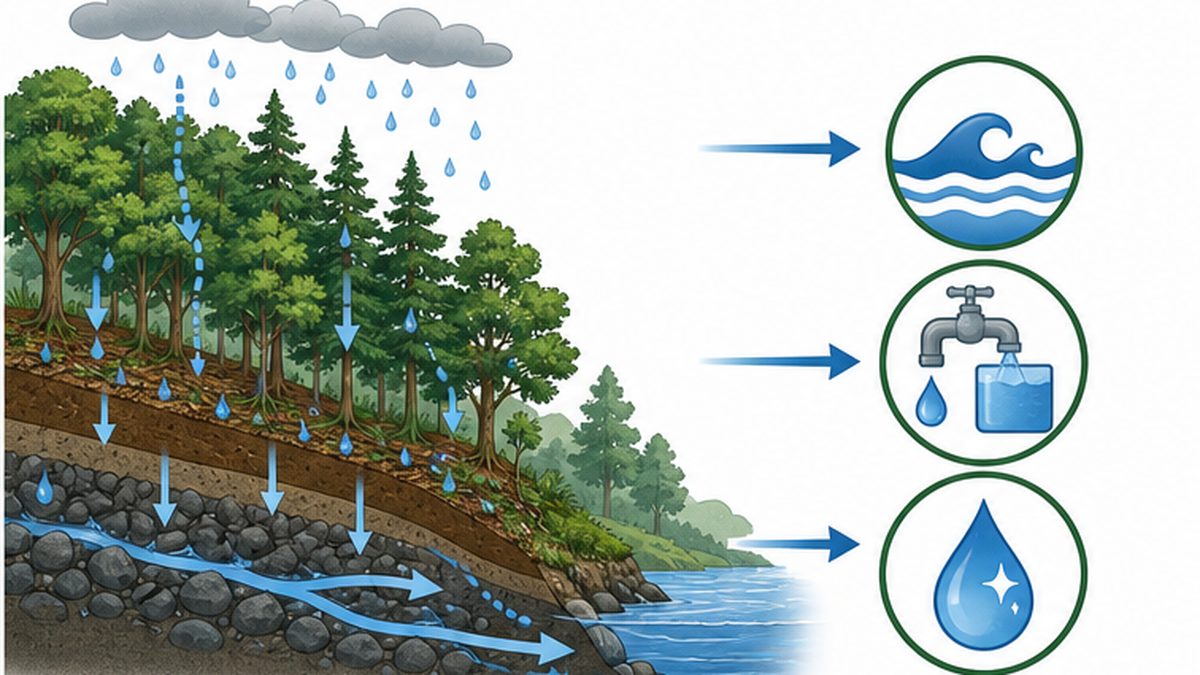
The 2001 report lists four components: flood mitigation, water resource storage, flow regulation and water purification. In practice these are usually bundled into three, and the Forestry Agency's technical guide narrows its focus further, to flood mitigation and water resource storage (flow regulation).
| Function | What it does | Where it works best |
|---|---|---|
| Flood mitigation | Prevents rainfall reaching the river all at once; lowers peak discharge and delays the peak | Small and medium floods |
| Water resource storage (flow regulation) | Releases water stored in soil and bedrock slowly, keeping rivers flowing through rainless periods | Normal flow to mild drought |
| Water purification | Turbidity is removed as water passes through the soil layer, yielding mineralised, near-neutral water | At all times |
Half of Japan's forest is "protection forest"
Japan has roughly 25 million hectares of forest, about two-thirds of its land area. Of that, 12.3 million hectares (actual area) is designated protection forest — 49.1% of the national forest area and 32.5% of the land area (as of 31 March 2025). Protection forest is forest where felling and changes to the land are restricted in order to serve a public purpose.
There are 17 categories of protection forest, and by far the largest is water-source protection forest: 9,280 thousand hectares (9.28 million ha) on a gross basis, 71.1% of the total. The figure shows clearly that water forms the backbone of Japan's forest protection system.
See the primary sourceForests that Nurture Water | Forestry Agency of JapanThe Forestry Agency's official explainer on how forests store rainfall and release it to rivers, with diagrams of the water source recharge function. (Japanese)🔗 rinya.maff.go.jpThe essentials
- What holds water is not the trees but the forest soil the trees have built
- Three pillars: flood mitigation, water resource storage, water purification
- 71.1% of Japan's protection forest (9.28 million ha) exists for water
How Rain Becomes a River — the Journey from Canopy to Groundwater
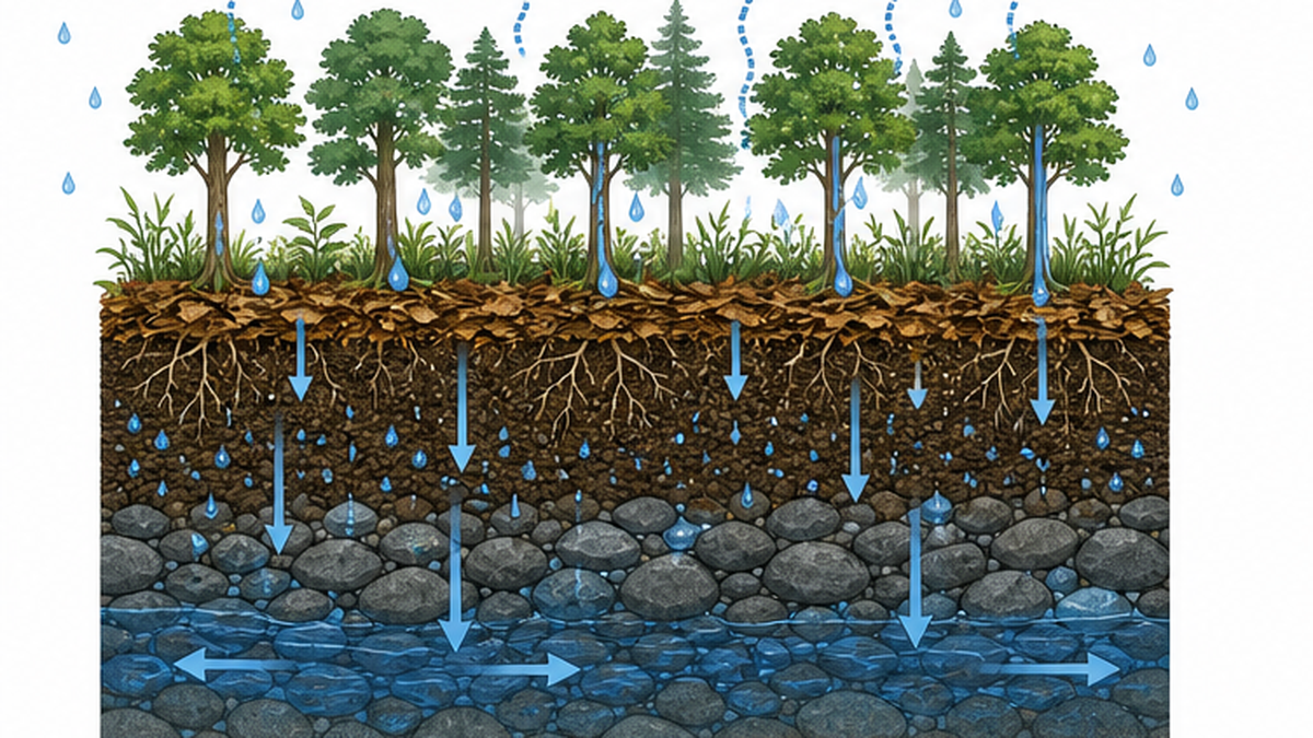
Rain falling on a forest does not go straight into the ground. It travels a long route — canopy → understorey → litter layer → soil → bedrock → river — before it becomes the stream water we see. Each stage plays a different role.
First barrier: 10–30% goes straight back to the sky
Branches and leaves catch the rain first. Some of the water clinging to them never reaches the ground and evaporates directly back into the atmosphere. This is canopy interception (interception evaporation). According to the Forest Research Institute, roughly 10–30% of rainfall is lost this way in Japanese forests.
"Lost" is the word, but seen from downstream this works in favour of flood reduction. A joint study by the Forest Research Institute, the University of Tokyo and Shizuoka University showed that interception evaporation reduces flood runoff; it was published online in the Journal of Hydrology in June 2023, using observations from the Ohoradani experimental catchment in Kanagawa Prefecture. The researchers argue that this distinctively forest phenomenon exerts a large influence on how floods play out.
The understorey catches rain too
Interception is not the work of the canopy alone. A survey of a 38-year-old Japanese cypress plantation in Tochigi Prefecture, six years after 50% strip thinning, found an interception rate of about 18% attributable to understorey vegetation (81% passing through, 1% as stemflow). Where dwarf bamboo and shrubs are established on the forest floor, they take one more layer of force out of the rain.
Once in the soil, water stays for years
The water source recharge function is hard to grasp intuitively because its timescale is nothing like human experience. A study of five nested forest catchments (0.84–75.28 ha) at the Hitachiota experimental site in Ibaraki Prefecture analysed the stable isotope ratios of oxygen and hydrogen in rainfall and stream water, and estimated that the mean residence time of stream water during rainless periods is 2.1 to 8.0 years (Kubota et al., 2007).
The water flowing in the stream today may be rain that fell several years ago. That is what "the forest stores water" really means. It is an entirely different order of magnitude from a reservoir that turns over in days or months.
Water moves in two layers: fast and slow
- Fast: overland flow and lateral flow. Reaches the river within hours and forms the flood peak
- Slow: water moving through fine soil pores and bedrock. Takes years to emerge as baseflow, the everyday water of the river
- The recharge function can be restated as: reducing the fast component and increasing the slow one
How Forest Soil Becomes a Dam — Pores, Aggregates and Measured Capacity
So how much water can forest soil actually hold? This is worth pinning down with numbers.
Capacity = porosity × soil depth
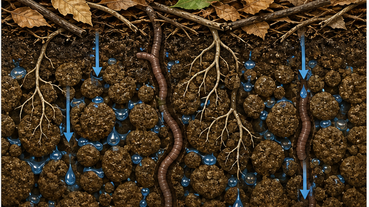
Forest soil is built from fine particles clustered into crumbs — aggregate structure. The gaps between aggregates are pores, and they are where water goes. Pores come in two kinds: fine capillary pores that retain water, and coarse non-capillary pores that transmit it. Water-holding capacity is calculated as porosity multiplied by soil depth.
Living roots, the channels left by decayed roots, and burrows made by earthworms and other soil fauna all create coarse pores, which is why forest soil both transmits and retains water better than soil under other land uses. The sequence is: trees build soil, and soil holds water.
Measured: 21 mm to 172 mm — a sevenfold spread by geology
Water-holding capacity measured by the Forest Research Institute at experimental sites across Japan (the volume retained in capillary pores) varies enormously with the parent geology.
| Site | Parent material | Soil water-holding capacity |
|---|---|---|
| Tsukuba (Ibaraki) | Volcanic ash | 172 mm |
| Hitachiota (Ibaraki) | Volcanic ash | 148 mm |
| Yamashiro Kitadani (Kyoto) | Granite | 140 mm |
| Katsura (Ibaraki) | Volcanic ash | 101 mm |
| Kahoku (Kumamoto) | Black metamorphic rock | 108 mm |
| Nagasawa Dam (Kochi) | Green metamorphic rock | 55 mm |
| Minami-Meijiyama (Okinawa) | Sandstone / mudstone | 50 mm |
| Jozankei (Hokkaido) | Quartz porphyry | 21 mm |
Capacity is large in catchments with thick volcanic ash deposits or deeply weathered granite, and small where only a thin soil sits on hard rock. It is not "forest means water" but rather "how thick a soil has developed, and on what geology". Two forests of identical area can differ completely in their real capability as a water source.
At catchment scale, roughly 100–200 mm
There is also a broader measure — catchment water-holding capacity — which includes the weathered rock layer beneath the soil. Estimates from forest catchment experiments put it broadly in the range of 100–200 mm depending on geology (Fujieda, 2007), organised by sedimentary and volcanic rock, volcanic ash and granite, and metamorphic rock. Again, catchments on volcanic ash or deeply weathered granite come out largest.
Is "beech forest absorbs 300 mm an hour" accurate?
Popular articles and tourist leaflets have widely repeated claims such as "the soil of primeval beech forest absorbs about 300 mm of rain per hour" or "up to 400 mm in the best forests". These are statements about infiltration capacity — how fast water can soak in — and not about storage capacity, how much can be held. However fast water soaks in, once the soil beneath is full, the water leaves. The two are easily confused, so whenever you meet a figure, check whether it is about speed or about volume.
How True Is the "Green Dam"? Flood Mitigation and Its Limits
This is the heart of the matter. Can forests replace dams? The answer is: up to a point they work remarkably well, but they are not a substitute for a dam.
The effect is real — in small and medium floods
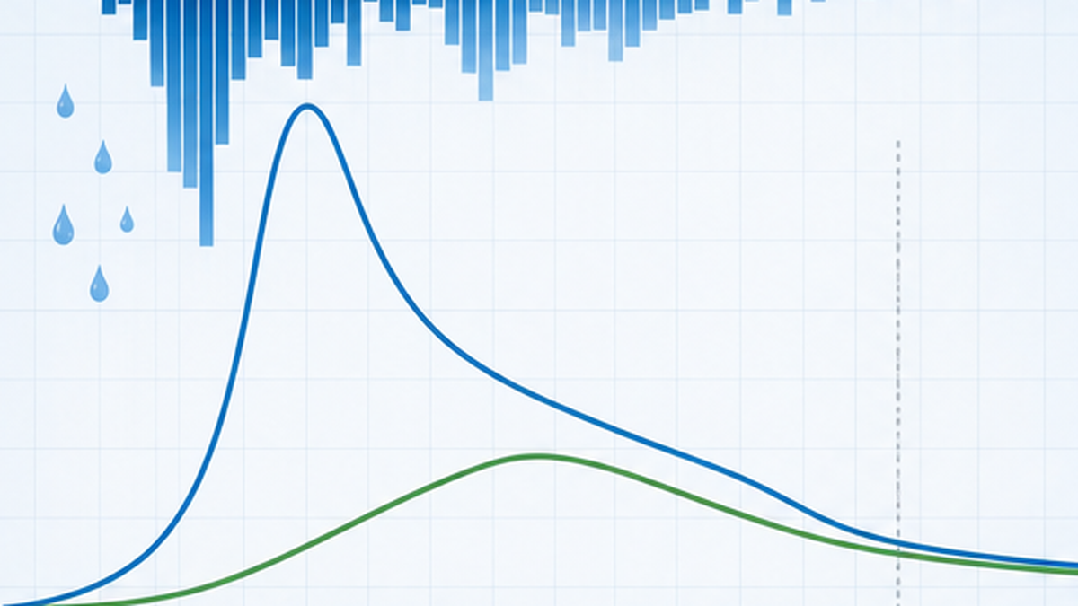
The Forestry Agency explains that rain infiltrating forest soil reaches the river slowly by a variety of pathways, lowering peak discharge during rainfall and delaying the timing of the peak. This flood mitigation function is described as particularly effective for small and medium floods. The estimate based on the Science Council of Japan report values it at 6.4686 trillion yen a year, calculated by the replacement-cost method: the difference in flow regulation between forest and bare ground under a 1-in-100-year rainfall, priced at the depreciation and annual maintenance cost of flood-control dams.
But once the soil saturates, that is the end of it
The problem is that this storage has a ceiling. Once the pores in the soil fill with water — once it saturates — additional rain goes almost entirely to runoff. At the moment a downpour fills a mountain's storage capacity, the forest stops being a device that stores water at all.
Motohisa Fujieda of the Forest Research Institute answers the question "can forests take the place of dams?" in three parts:
- The water-holding capacity of forests is comparable in volume to the flood-control capacity of a multipurpose dam
- That capacity can reduce direct runoff, but it cannot regulate flood peak discharge the way a dam can
- Excessive expectations of forest water-holding capacity carry large risks in the face of concentrated downpours and typhoons driven by extreme weather
Take only the first point and forests sound equal to dams; take only the third and they sound useless. The honest reading takes all three together. Forests have capacity, but that capacity cannot be operated. There is no way to adjust the release and shift the peak downstream.
It does not follow that flood-control structures are unnecessary
In Japan's river planning, forest water-holding capacity is incorporated into models as a "saturation rainfall" parameter — but as one of the assumptions in a flood-control plan, not as a substitute for levees or dams. Forest management and engineered flood control are not alternatives; they are two wheels with different jobs.
Climate change is increasing the share of "rain after saturation"
This limit will weigh more heavily over time. Japan Meteorological Agency AMeDAS records show that the annual number of extremely intense rainfall events (hourly rainfall of 80 mm or more) has been increasing since observations began in 1976. In 2016, a typhoon brought about 600 mm of rain in 24 hours to Minamifurano, Hokkaido (maximum radar-analysed value), and the Sorachi River burst its banks — a scale of downpour that had been hard to imagine in Hokkaido.
Because forest storage has a ceiling, the more rainfall concentrates, the greater the proportion of "rain after saturation". The same forest delivers proportionally less mitigation as the character of the rain changes.
Worse, heavy rain damages the forest itself. The Forestry Agency's technical guide includes simulations that apply the actual rainfall of Typhoon No. 20 in 2018 (219.5 mm total, 33.5 mm peak hourly) and Typhoon No. 19 in 2019 (518 mm total, 81.5 mm peak hourly) and calculate how the catchment water balance — evapotranspiration, overland flow, lateral flow, groundwater flow and deep percolation — shifts as the proportion of landslide scars changes. When a slope fails it becomes bare ground with low infiltration, so the next downpour sends still more water across the surface: disaster erodes the very recharge function of the forest.
Where the green dam works, and where it does not
- Works: peak reduction and delay in small to medium floods, stable flow in normal conditions, suppression of sediment runoff
- Does not work well: record downpours after the soil has saturated. Deliberate control of peak discharge is impossible
- Conclusion: forest management is the foundation of flood control, and functions only in combination with dams, levees and evacuation systems
Drought and Water Storage — More Forest Does Not Mean More Water
The other face of the recharge function is easing drought. Here, though, sits a fact that runs against intuition.
What the basic water balance equation tells us
Water in a catchment obeys a simple identity:
Precipitation = runoff + evapotranspiration
― The fundamental water balance equation of forest hydrology
Read plainly, this means that as evapotranspiration rises, runoff falls. And forests, through transpiration from leaves and interception evaporation, consume far more water than grassland or bare ground. The Forest Research Institute's own summary of the evidence is explicit:
- Forests infiltrate most rainfall into the soil and move it as subsurface water; because that movement is slower and less uniform than surface flow, river rises are moderated
- Forests consume soil water through transpiration, reducing annual runoff
- Water consumption is proportional to leaf quantity, so coniferous forest consumes more water than broadleaf forest
So "plant trees and the river will carry more water" is, in annual totals, the opposite of the truth. More forest means more evapotranspiration and less annual runoff. Describing headwater forest projects as a way to "increase water volume" therefore conflicts with the evidence.
Why headwater forests still matter
That does not make them worthless. The point is distribution, not total volume.
- Even as the total falls, the share that pours out during floods falls and the share released slowly (baseflow) rises
- Water held in capillary pores sustains river flow through rainless periods
- The water supplied is low in turbidity, close to neutral, and moderately mineralised
- Soil erosion is suppressed, reducing sediment inflow and turbidity in dams and rivers
What matters for a water utility or for irrigation is not "how many hundred million tonnes flowed this year" but "is it flowing steadily, at a usable quality, when we need it?" That reliable supply is precisely what headwater forests provide. The Science Council of Japan estimates value water resource storage at 8.7407 trillion yen a year and water purification at 14.6361 trillion yen — the latter second only to surface erosion prevention (28.2565 trillion yen) among forest functions.
| Function | Annual valuation | Method (replacement cost) |
|---|---|---|
| Surface erosion prevention | ¥28.2565 trillion | Difference in eroded sediment between forested and unforested land, priced at check dam construction cost |
| Water purification | ¥14.6361 trillion | Domestic-water share priced at water rates; the rest at depreciation etc. of rainwater treatment facilities |
| Shallow landslide prevention | ¥8.4421 trillion | Difference in failure area between forested and unforested land, priced at slope works cost |
| Water resource storage | ¥8.7407 trillion | Storage derived from precipitation and evapotranspiration, priced at water-supply dam costs |
| Flood mitigation | ¥6.4686 trillion | Flow regulation under a 1-in-100-year rainfall, priced at flood-control dam costs |
| Carbon dioxide absorption | ¥1.2391 trillion | Absorption derived from biomass increase, priced at CO2 capture cost |
How to read these valuations
These figures come from the replacement-cost method: what it would cost to reproduce each function artificially if the forest were absent. No money of that size actually changes hands, and it is not a price at which forests could be sold. The Ministry of Agriculture, Forestry and Fisheries states plainly that "because evaluation methods differ by type of function, no total is given". Summing them up and declaring "forests are worth 70 trillion yen a year" departs from the practice of the official sources.
Under-Managed Plantations Weaken Water — What Infiltration Measurements Show
The recharge function is not something a forest delivers automatically just by existing. How water soaks in changes by orders of magnitude with the condition of the forest. Field measurements by the Forestry Research Institute of the Hokkaido Research Organization make this unmistakable.
Infiltration measured at 108 sites in Okhotsk
The survey covered the Tokoro and Abashiri river basins — both major Class A river systems draining into the Sea of Okhotsk — selecting 108 sites across differing forest types and measuring infiltration by the ponding method: a 30 cm metal cylinder driven into the ground, with the fall in water level recorded over 180 minutes (Abe and Sato, 2008; Koshunai Kiho No. 181). Adjusted so that other factors sit at average values, the results were as follows.
| Forest type | Infiltration capacity | Notes |
|---|---|---|
| Broadleaf natural forest (high stock) | 412–422 mm/h | No appreciable difference between high and low stock |
| Broadleaf natural forest (low stock) | 412–422 mm/h | — |
| Larch plantation (30+ years) | 310 mm/h | Lower than natural forest |
| Sakhalin fir plantation (50+ years) | 307 mm/h | Lower than natural forest |
| Clear-cut and replanted sites | 103 mm/h | Some sites as low as 1–30 mm/h |
| Machinery skid roads | 29 mm/h | Lowest of all classes; some sites 1–30 mm/h |
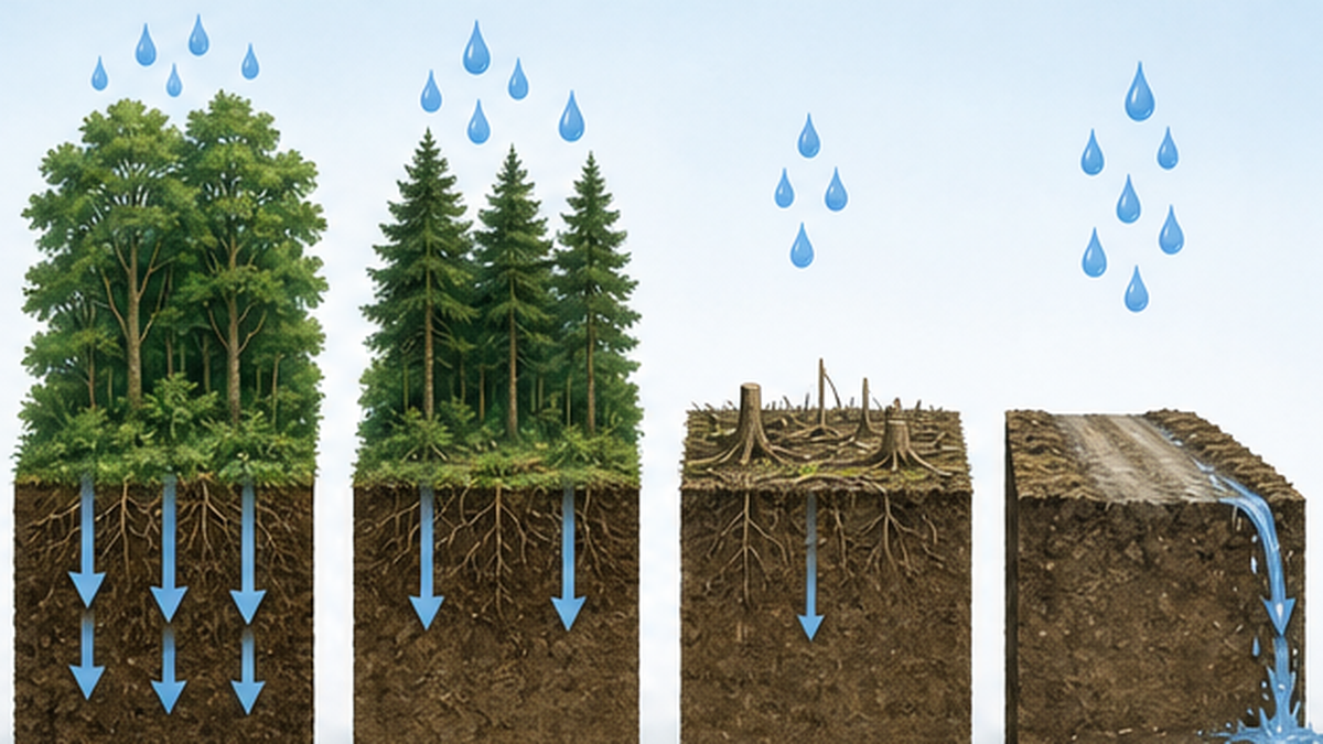
Against 412 mm/h in natural forest, a road driven over by machinery manages 29 mm/h — less than one-fourteenth. In 30 mm of rain in an hour, natural forest absorbs all of it while the skid road overflows and water runs across the surface. Surface flow strips soil, carries turbidity and reaches the river all at once.
The deciding factor is whether anything grows on the forest floor
In the same survey, the factor that mattered alongside forest type was understorey cover. Where total understorey cover was 100%, infiltration measured 288 mm/h; where cover fell to 90% or below, it dropped to 105–108 mm/h — down by roughly two-thirds.
And in Japanese cypress plantations on Honshu, a well-known chain of events follows: insufficient thinning darkens the stand and the understorey disappears. The floor of a plantation that admits no light turns bare; raindrops strike the soil directly and compact the surface; infiltration falls. Soil washes away, roots are exposed, and still less water soaks in. This vicious circle is what under-managed plantations are living through.
See the measured dataForestry that Protects Water and Soil: On Infiltration Capacity | Hokkaido Research Organization, Forestry Research InstituteField measurements at 108 sites in the Tokoro and Abashiri river basins, comparing infiltration capacity across natural forest, plantations, clear-cut sites and skid roads (Koshunai Kiho No. 181). (Japanese)🔗 hro.or.jp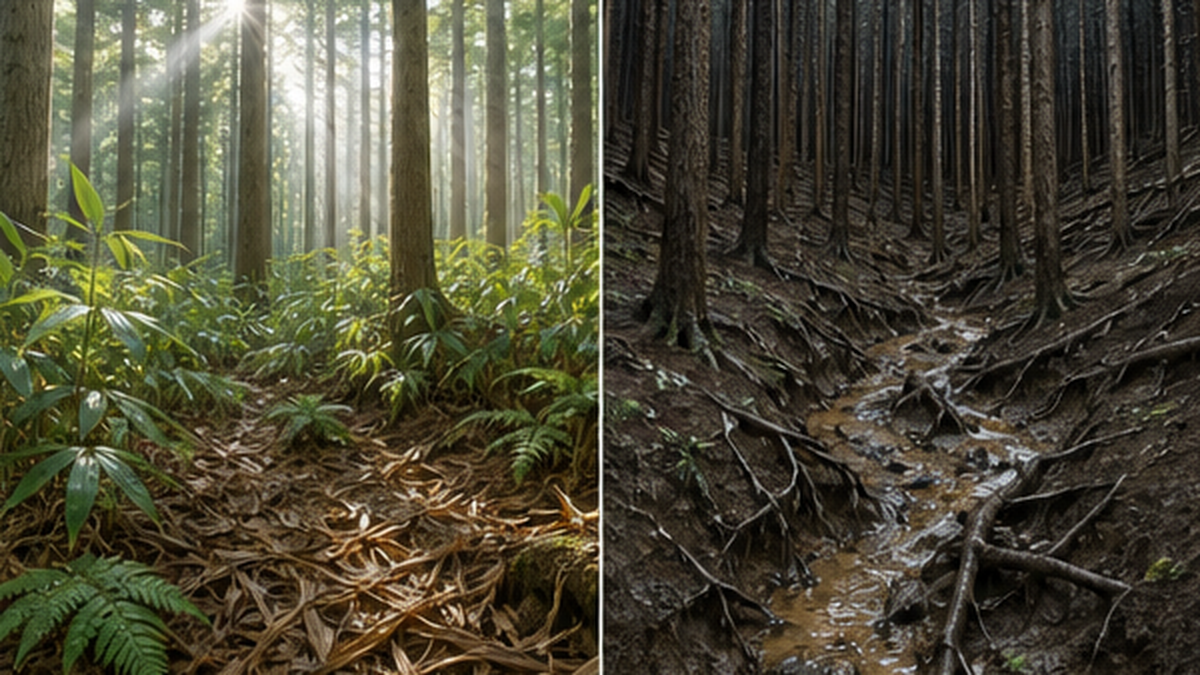
Forest management as climate adaptation
As the character of rainfall changes, business as usual will not keep up. The direction of travel looks roughly like this.
- Stands that keep an understorey: thin to admit light and hold infiltration at a high level
- Diversity of species and age classes: even-aged monocultures are vulnerable to pests, windthrow and weather damage, and damage spreads widely
- Proper design and maintenance of forest roads: disperse surface flow from skid roads, where infiltration falls furthest, through road drainage
- Prompt replanting after clear-felling: shorten the bare-ground period and prevent soil loss
- Combination with engineered measures: plan forest management together with flood-control structures and evacuation systems
- Consensus across the catchment: decide how downstream water users and companies share the cost of upstream forest management
A forest is not natural infrastructure that works if left alone; it is infrastructure whose performance depends on the standard of care it receives. And the forestry workforce that provides that care keeps shrinking. The future of headwater forests is a question of who does the work and who pays for it, as much as a question of technique.
From Forest to Sea — How Headwater Forests Support the Coast
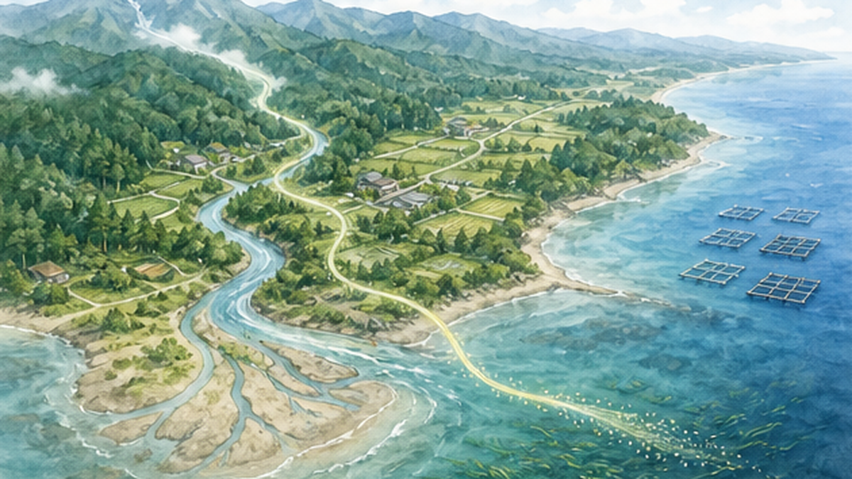
Headwater forests are usually discussed as a drinking-water issue. But river water ends up in the sea. The condition of a forest reaches all the way to the tidal flats, seagrass beds and coastal fisheries at the river mouth.
"The forest is longing for the sea" — a movement that began in Kesennuma
Shigeatsu Hatakeyama, an oyster farmer from Kesennuma in Miyagi Prefecture (who died on 3 April 2025, aged 81), led the movement known as Mori wa Umi no Koibito — "the forest is longing for the sea" — from 1989. Built around tree-planting festivals on Mount Murone in Iwate Prefecture, upstream on the Ōkawa River that flows into Kesennuma Bay, it set out to make the connections between forest, river and sea tangible. The starting point was that oyster growers knew from experience how much their harvest depended on river water.
What made the movement remarkable is that it was fishers who went to the mountains to plant trees. It carried into public life, as a citizens' movement, the idea of treating a catchment as a single unit — the principle that upstream forest management underpins downstream and coastal productivity. It continues today as an NPO running planting festivals and hands-on learning for children.
See their workMori wa Umi no Koibito (The Forest is Longing for the Sea), NPOTree-planting festivals and hands-on learning that have continued in Kesennuma, Miyagi Prefecture since 1989, communicating the links between forest, river and sea. (Japanese)🔗 mori-umi.orgHow much of the "fulvic acid iron" story is established?
The forest–sea connection is often explained through fulvic acid iron: humic substances in forest soil (fulvic and humic acids) bind with iron ions, travel down rivers in dissolved form, and are taken up by seaweed and phytoplankton.
There is real chemistry behind this. In seawater, iron(II) readily oxidises to iron(III) and precipitates, leaving very little dissolved iron biologically available. So a source of iron that stays dissolved by binding to organic matter genuinely matters.
There is experimental evidence too. In a fertilisation trial using steelmaking slag and humic substances at Shakuma beach in Mashike, Hokkaido, begun in October 2004, kelp and other large seaweeds had established a dense stand by June 2005, and the wet weight of seaweed in the treated plot exceeded the control by roughly 230 times (Mitsuo Yamamoto, University of Tokyo).
But the quantitative contribution of forest iron is still being tested
That experiment demonstrates the effect of deliberately applying iron and humic substances. It does not directly show what fraction of coastal productivity is explained by iron supplied naturally from forests. Coastal productivity involves temperature, nutrients, light, currents and grazing, and cannot be explained by iron alone. The forest–sea connection is real, but the breakdown of the mechanism and its quantitative weight remain open research questions — a distinction worth stating honestly.
What is well established: sediment, nutrients and turbidity
Setting the iron debate aside, the following pathways from forest to sea are comparatively well established.
- Sediment and turbidity: by suppressing surface erosion, forests reduce the turbid water and sediment reaching rivers. Turbidity directly degrades the light environment of seagrass beds and coral reefs
- The quantity and quality of nutrient runoff: water that has passed through forest soil is less prone to sudden nitrogen and phosphorus loads. Excess nutrients drive coastal eutrophication and red tides (see Where nitrogen and phosphorus in the sea come from)
- Stable flow: salinity in the estuary changes less abruptly, keeping conditions steady for brackish-water life
Conversely, when upstream forests degrade and topsoil washes away, estuarine tidal flats silt up and turbidity settles over seagrass beds. Kelp barrens, an increasing problem around Japan, are discussed with land-derived environmental change as one contributing factor alongside warming water and urchin grazing. The concept of satoumi — the idea that human care can make the sea richer — likewise rests on these catchment connections.
Policy and Economics — Protection Forest, Forest Environment Tax, and Measuring Recharge
The systems that protect headwater forests are, in fact, layered on top of one another.
Protection forest: restricting felling to protect water
The oldest and strongest instrument is the protection forest system. Once land is designated as water-source protection forest, felling and changes to the land require permission, and a certain forest condition must be maintained. As noted, 9.28 million hectares is designated on a gross basis. On an actual-area basis, national forest accounts for 6,921 thousand hectares (56.3%) and private forest for 5,377 thousand hectares (43.7%) — the state carries the larger share.
Forest environment tax: everyone in Japan has been paying since FY2024
From FY2024, a national tax of 1,000 yen per person per year has been levied through the per-capita portion of individual residence tax. This is the forest environment tax. The revenue is distributed as forest environment transfer tax to municipalities and prefectures according to objective criteria: private plantation area, number of forestry workers, and population.
Municipalities may spend it on "measures for forest development" such as thinning, and on "measures to promote forest development" including workforce training, timber use and public awareness. The transfer tax itself began earlier, in FY2019, and according to the Forestry Agency municipal forest works including thinning have expanded to about 64,000 hectares — more than ten times the FY2019 figure.
Check the schemeForest Environment Tax and Forest Environment Transfer Tax | Forestry AgencyOfficial explanation of the national tax of 1,000 yen per person per year introduced in FY2024, and how the transfer tax is distributed to municipalities. (Japanese)🔗 rinya.maff.go.jpIn other words, everyone living in Japan is now contributing 1,000 yen a year towards the care of headwater forests. Many municipalities publish where that money goes, which makes it a convenient way into the subject.
Putting a number on "recharge"
A recent development is the effort to evaluate the recharge function quantitatively. The Forestry Agency published its technical guide in March 2023 and then commissioned work on a simplified quantitative method. In March 2026 an explanatory document and a calculation spreadsheet were released, defining recharge as "the volume of water a forest catchment recharges to groundwater and that can contribute to baseflow", and setting out recharge coefficients of 0.05 to 0.5 for forest — that is, an assumption that forests recharge roughly one to five tenths of precipitation to the water source.
The practical motivation is clear. "Water positive" commitments, under which a company recharges as much water in a catchment as it uses, and corporate funding for headwater forest conservation, both require the ability to say how many cubic metres of additional recharge a given piece of forest management delivered per year.
Read the guide (PDF)Technical Guide to the Water Source Recharge Function of Forests (March 2023) | Forestry AgencyA single volume gathering research on canopy interception, infiltration, residence time and flood mitigation (PDF). The principal source for this article. (Japanese)🔗 rinya.maff.go.jpThe difficulty of evaluation is stated frankly
The Forestry Agency's own guide states that "even now it is extremely difficult to evaluate a whole catchment accurately; rainfall and runoff experiments and analyses can be carried out over very limited plots, but analysis at the broad scale of an entire mountain covering multiple catchments presents difficulties". An official document acknowledging its own uncertainty is a sign of integrity — and a reminder to us not to treat the numbers as absolute.
In Summary: Value Forests Properly, Without Making Them Omnipotent Dams
To gather up what this article has established.
- It is forest soil, not the trees, that holds water. Porosity times soil depth determines capacity, and geology produces a spread of more than sevenfold, from 21 mm to 172 mm
- Rain passes canopy interception (10–30%), understorey, litter layer, soil and bedrock, taking 2.1 to 8.0 years on average to emerge as stream water
- Flood mitigation works in small and medium floods. Once the soil saturates that is the end of it, and peak discharge cannot be regulated deliberately
- More forest means more evapotranspiration, so annual total runoff actually falls. The value lies not in volume but in distribution and reliable quality
- Neglect measurably weakens the water function. Against 412 mm/h in natural forest, skid roads manage 29 mm/h, and infiltration falls by roughly two-thirds once understorey cover drops below 90%
- Forest, river and sea are continuous. Through sediment and turbidity, nutrient runoff and stable flow, upstream forests reach coastal productivity
The phrase "green dam" has real power to convey the value of forests. But if it takes on a life of its own and becomes "forests are all we need", it will lead people to misjudge the risk of extreme rainfall. Forests hold great capacity, but it cannot be operated. Their effect is broad, but not unlimited. This measured understanding is, in the end, what will protect forests.
What you can do today
- Find out which river, reservoir and forest your tap water comes from — water utilities almost always publish this
- Check what your municipality is doing with its forest environment transfer tax; most publish how it is spent
- Join a planting or thinning day in a headwater forest, or a catchment environmental education programme
- Choose domestic timber, products made from thinnings, and wood carrying forest management certification
- Walk a river and its estuary, and see for yourself how the forest upstream connects to the sea downstream
Have you ever listened to rain inside a forest? The sound of it striking leaves, running down trunks, being swallowed by fallen litter. Every one of those sounds becomes, years later, water in a stream, then a river, then the sea. To protect a headwater forest is to hand that long thread of time on to the next generation.
References and sources
- Forestry Agency of Japan – Technical Guide to the Water Source Recharge Function of Forests (March 2023, Japanese)
- Forestry Agency of Japan – Forests that Nurture Water — basic explanation of the recharge function (Japanese)
- Science Council of Japan – Evaluation of the Multifunctional Roles of Agriculture and Forests in Relation to the Global Environment and Human Life (report, November 2001, Japanese)
- Ministry of Agriculture, Forestry and Fisheries – Multifunctional roles of forests — monetary valuation by function based on the Science Council of Japan report (Japanese)
- Forestry Agency of Japan – Area of protection forest (as of 31 March 2025, Japanese)
- Motohisa Fujieda (Forest Research Institute) – Unravelling the Mysteries of Forests and Water — towards understanding the water source recharge function (Japanese)
- Tomoyuki Abe (Hokkaido Research Organization, Forestry Research Institute) – Forestry that Protects Water and Soil: On Infiltration Capacity (Koshunai Kiho No. 181, February 2017, Japanese)
- Forest Research and Management Organization, Forest Research Institute – Assessing the downstream impact of interception evaporation — a distinctively forest phenomenon that strongly influences floods (5 July 2023, Japanese)
- Mitsuo Yamamoto (University of Tokyo) / Ocean Policy Research Institute, SPF – Towards restoring the "forest of the sea": kelp bed recovery using steelmaking slag and humic substances (Ocean Newsletter No. 201, Japanese)
- Forestry Agency of Japan – Forest Environment Tax and Forest Environment Transfer Tax (Japanese)
* Listed in order of reliability: government and academic institutions > peer-reviewed papers > specialist bodies > trusted media